Tr:Key:boundary
 |
| Açıklama |
|---|
| boundary etiketi çesitli sınırları belirlemekte kullanılır. |
| Grup: Location |
| Bu unsurlarla kullanılır |
| Belgelenmiş değerler: 37 |
| Yararlı kombinasyonlar |
| Durum: de fakto |
| Bu etiket için araçlar |
Özet
...
Bakınız
- Talk:Key:boundary#Admin_level_for_Turkey
- admin_level=*
- border_type=*
Türkiye için, öbür ülkelerde seçilen değerlere uygun olarak, su değerleri kullanalim:
- admin_level=2 Türkiye etrafindaki kara sınırları
- admin_level=4 Bölge sınırları
- admin_level=6 İl sınırları
- admin_level=7 İlçe sınırları
- admin_level=8 Bucak sınırları
- admin_level=9 Köy sınırları
- admin_level=10 Mahalle sınırları
Ayrıca NUTS sayfasınada bakınız.
Temel değerler
| admin_level= | ||||||||||
|---|---|---|---|---|---|---|---|---|---|---|
| Country | 1 | 2 | 3 | 4 | 5 | 6 | 7 | 8 | 9 | 10 |
| N/A | Türkiye etrafindaki kara sınırları | N/A | Bölge sınırları
NUTS 1 |
N/A
NUTS 2 |
İl sınırları
NUTS 3 |
N/A | İlçe sınırları
LAU 1 (aka NUTS 4) |
N/A
LAU 2 (aka NUTS 5) |
Şehir sınırları | |
|
|
N/A | national border | N/A | federal states border
Bundesland NUTS 1 |
state-district border
Regierungsbezirk NUTS 2 |
county borders
Landkreis / Kreis / kreisfreie Stadt NUTS 3 |
amt
Samtgemeinde, Verwaltungsgemeinschaft LAU 1 (aka NUTS 4) |
Towns, Municipalities / City-districts
Stadt, Gemeinde LAU 2 (aka NUTS 5) |
Parts of a municipality with parish councils /self_government
Stadtbezirk / Gemeindeteil mit Selbstverwaltung |
Parts of a municipality without ...
Stadtteil / Gemeindeteil ohne Selbstverwaltung
|
| Key | Value | Element | Comment | Rendering example | Photo | |
|---|---|---|---|---|---|---|
Boundary types | ||||||
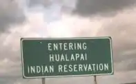
| boundary | aboriginal_lands | A boundary representing official reservation boundaries of recognized aboriginal / indigenous / native peoples. |  |
 | ||
| boundary | administrative | Yönetim bölümleri (şehir, ülke, vs.) için kullanınız. Türkiye için önerdiğim değerleri bu sayfanın başında bulabilirsiniz. |  |
 | ||
| boundary | border_zone | A border zone is an area near the border where special restrictions on movement apply. Usually a permit is required for visiting. | _-_crop.jpg.webp) | |||
| boundary | forest | A delimited forest is a land which is predominantly wooded and which is, for this reason, given defined boundaries. It may cover different tree stands, non-wooded areas, highways… but all the area within the boundaries are considered and managed as a single forest. | 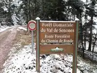 | |||
| boundary | forest_compartment | A forest compartment is a numbered sub-division within a delimited forest, physically materialized with visible, typically cleared, boundaries. | 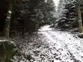 | |||
| boundary | hazard | A designated hazardous area, with a potential source of damage to health, life, property, or any other interest of value. | 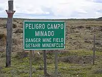 | |||
| boundary | maritime | Maritime boundaries which are not administrative boundaries: the Baseline, Contiguous Zone and EEZ (Exclusive Economic Zone). | 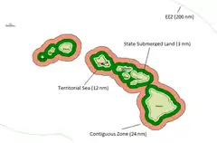 | |||
| boundary | marker | A boundary marker, border marker, boundary stone, or border stone is a robust physical marker that identifies the start of a land boundary or the change in a boundary, especially a change in direction of a boundary. See also historic=boundary_stone | 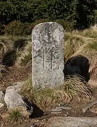 | |||
| boundary | national_park | Area of outstanding natural beauty, set aside for conservation and for recreation (Other languages). | 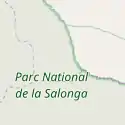 |
 | ||
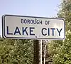
| boundary | place | boundary=place is commonly used to map the boundaries of a place=*, when these boundaries can be defined but these are not administrative boundaries. | ||||
| boundary | political | Electoral boundaries | ||||
| boundary | postal_code | Postal code boundaries | ||||
| boundary | protected_area | Protected areas, such as for national parks, marine protection areas, heritage sites, wilderness, cultural assets and similar. | 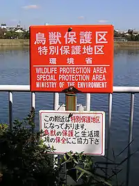 | |||
| boundary | special_economic_zone | A government-defined area in which business and trade laws are different. |  | |||
| boundary | disputed | An area of landed claimed by two or more parties (use with caution). See also Disputed territories. | 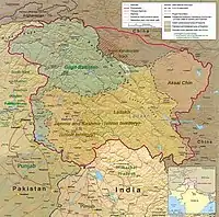 | |||
| boundary | user defined | All commonly used values according to Taginfo | ||||
Attributes | ||||||
| admin_level | (number) | Applies to boundary=administrative and is usually in the range 1 to 10, except for several countries (Bolivia, Germany, Mozambique, Netherlands, Philippines, Poland, Turkmenistan, Venezuela) where it is in the range 1 to 11 – see boundary. | 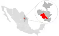 | |||
| border_type | * | To distinguish between types of boundary where admin_level isn't enough. Used in several different ways e.g in maritime contexts. | ||||
| start_date | (date) | Useful if the boundary is very recent (or if it will become effective in a near future). |  | |||
This table is a wiki template with a default description in English. Editable here.
This article is issued from Openstreetmap. The text is licensed under Creative Commons - Attribution - Sharealike. Additional terms may apply for the media files.