Tag:water=stream
 |
| Description |
|---|
| The water covered area of a stream: a naturally-formed watercourse which is narrower than a river |
| Group: Water |
| Used on these elements |
| Requires |
| Useful combination |
| See also |
| Status: de facto |
| Tools for this tag |
|
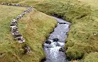
The tag water=stream is sometimes used with natural=water to micro-map the water covered area of a stream. Should contain a waterway=stream way inside.
This tag is not very common, because a waterway=stream is defined as a naturally-formed waterway which is narrow enough that an active, able-bodied adult can jump across it. Usually, the precise area of a stream is too narrow to be mapped unless there is very high resolution aerial imagery available.
Also see the more common tag water=river which is used to map the area of a river: a natural watercourse which is too wide to be jumped across.
How to map
Draw the outline ![]() of the stream and add natural=water + water=stream.
of the stream and add natural=water + water=stream.
For long streams the area should be split into several segments of manageable size.
In addition a way ![]() tagged as waterway=stream, must be drawn in the direction of the river flow. All tags of the stream (like name=* and other supplemental tags) should go to this centre line.
tagged as waterway=stream, must be drawn in the direction of the river flow. All tags of the stream (like name=* and other supplemental tags) should go to this centre line.