Tag:water=ditch
 |
| Description |
|---|
| The water covered area of a waterway=ditch - a simple artificial waterway serving as a barrier or for draining surrounding land. |
| Group: Water |
| Used on these elements |
| Requires |
| Useful combination |
| See also |
| Status: de facto |
| Tools for this tag |
|
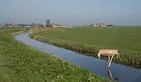
The tag water=ditch is used with natural=water to map the water covered area of a waterway=ditch: a simple artificial waterway serving as a barrier or for draining surrounding land. Should contain a waterway=ditch way inside.
How to map
Draw the ditch ![]() area outline.
area outline.
If the ditch is very long, it must be divided into several segments.
Add natural=water and water=ditch.
Also map a separate ![]() way with waterway=ditch in the direction of water flow.
way with waterway=ditch in the direction of water flow.
Tags used in combination
- name=* - if the ditch has a commonly used name
- intermittent=yes - if the ditch is intermittently filled with water
See also
- water=moat - A moat: a deep, wide defensive ditch, normally filled with water, dug to surround a fortified habitation
- water=canal - the water area of a canal, a man-made channel for water. Contains a waterway=canal way inside.
- water=drain - the water area of a drain, an artificial waterway used for carrying superfluous water, lined with concrete or similar. Contains a waterway=drain way inside.
- water=river - the area of a river. Contains a waterway=river way inside.
This article is issued from Openstreetmap. The text is licensed under Creative Commons - Attribution - Sharealike. Additional terms may apply for the media files.