Tag:usage=spillway
 |
| Description |
|---|
| Specific waterway usage allowing the controlled release of water from a waterbody (reservoir, canal, river) |
| Group: Man made |
| Used on these elements |
| Requires |
| Useful combination |
| Status: approved |
| Tools for this tag |
|
An artificial structure channelling water which allows it release from a water body, either under controlled circumstances or as a means of ensuring that water levels do not overtop and destroy containing structures (dams, levees). Spillways will normally be free of water but remains dangerous since it can be expected at any time.
Spillways may be in regular use or designed only to be used in emergencies.
How to map
See waterway=river for common guidelines on how to map waterways.
All spillways can be drawn as ways ![]() and tagged with waterway=canal + usage=spillway.
and tagged with waterway=canal + usage=spillway.
Larger spillways can be completed with an area ![]() and tagged with natural=water + water=canal + usage=spillway.
and tagged with natural=water + water=canal + usage=spillway.
As any waterway, spillways should connect to the water body which it drains and to the downstream outlet.
The material=* of the spillway should be added.
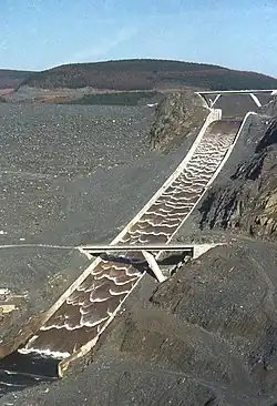
The recent near collapse of the ![]() Oroville Dam was in part precipitated because the emergency spillway was largely earth.
Oroville Dam was in part precipitated because the emergency spillway was largely earth.
Wikipedia mentions different types of spillways, use spillway:type=* to describe these.
Related tags
- waterway=dam - Spillways will most usually be mapped in association with dams
- natural=water + water=reservoir - Water area impounded behind.
- power=generator + generator:source=hydro - A spillway is often associated with hydropower power plants.
- emergency=siren + siren:purpose=flood – a siren that warns a downstream area of an impending discharge
- hazard=*