Tag:landuse=basin
 |
| Description |
|---|
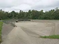
| An area of land artificially graded to hold water. |
| Rendering in OSM Carto |
 |
| Group: Landuse |
| Used on these elements |
| Useful combination |
|
| See also |
| Status: de facto |
| Tools for this tag |
|
An area of land artificially graded to hold water. Note that this definition includes also structures typically without water. Usually these features are made for man made water courses e.g. storm water, water treatment.
It is treated as synonymous to natural=water in many renderings, including JOSM editor.
How to tag
Applies to ![]() nodes and
nodes and ![]() areas.
areas.
- landuse=basin
- basin=infiltration — An
 infiltration basin catches storm water and allows it to seep into an aquifer.
 - basin=detention — A detention basin catches storm water and allows it to drain slowly into natural waterways.
- basin=retention — A retention basin catches storm water and retains it, forming an artificial pond.
- basin=evaporation — A evaporation pond or evaporation basin used to evaporate water containing a dissolved substance (precipitate)
- basin=infiltration — An
Tags used in combination
- name=<name of the basin>
- basin=* - refines the type of the basin
- intermittent=yes - If the presence of water is intermittent.
Rendering

River basins
Do not use this tag for land form (natural) basins e.g. the Amazon Basin. There are no tags (yet, 2018) in OSM for mapping such features.
Possible synonyms
See also
- natural=water + water=basin - Synonym for landuse=basin
- leisure=swimming_pool - A swimming pool (water area only)
- amenity=kneipp_water_cure - A foot bath is a shallow pool, often with handrail.
- natural=water + water=pond - a small body of standing water, man-made in most cases
- natural=water + water=reservoir - a man made body of stored water, usually formed by a dam across a valley or natural depression
- landuse=salt_pond - A salt pond, salt evaporation pond or saltern
- natural=water - Any body of water, from natural such as a lake or pond to artificial like moat or canal
- water=* - Specification of a water body
| ||||||||||||||||||||||||||||||||
This article is issued from Openstreetmap. The text is licensed under Creative Commons - Attribution - Sharealike. Additional terms may apply for the media files.