Tag:building=presbytery
 |
| Description |
|---|
| A building that was built as a presbytery (where priests live and work). |
| Rendering in OSM Carto |
 |
| Group: Buildings |
| Used on these elements |
| Useful combination |
|
| Status: in use |
| Tools for this tag |
|
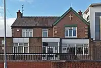
A building where priests live and work.
How to map
Draw as an ![]() along the building outline. In cases where it is impossible one may set a
along the building outline. In cases where it is impossible one may set a ![]() instead. Tag it with building=presbytery.
instead. Tag it with building=presbytery.
Additional tags
- name=*
See also
- amenity=place_of_worship - A place where religious services are conducted
- building=cathedral - A building that was built as a cathedral
- building=chapel - Building built as chapel
- building=church - A building that was built as a church
- building=mosque - A building that was built as a mosque
- building=temple - A building that was built as a temple
- building=synagogue - A building that was built as a synagogue
- building=shrine - A building that was built as a shrine
This article is issued from Openstreetmap. The text is licensed under Creative Commons - Attribution - Sharealike. Additional terms may apply for the media files.