Tag:basin=retention
 |
| Description |
|---|
| A retention basin catches stormwater and retains it, forming an artificial pond. |
| Rendering in OSM Carto |
 |
| Group: Water management |
| Used on these elements |
| Requires |
|
or |
| Status: de facto |
| Tools for this tag |
|
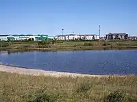
A retention basin is an artificial pond with vegetation around the perimeter, and includes a permanent pool of water in its design. It is used to manage stormwater runoff to prevent flooding and downstream erosion, and improve water quality in an adjacent river, stream, lake or bay.
The basin is normally filled with water.
How to map
Draw as an area ![]() along the outline of the basin and add
along the outline of the basin and add
or
See also
- basin=detention - detention basin catches storm water and allows it to drain slowly into natural waterways.
- basin=infiltration - infiltration basin catches storm water and allows it to seep into an aquifer.
This article is issued from Openstreetmap. The text is licensed under Creative Commons - Attribution - Sharealike. Additional terms may apply for the media files.