Tag:amenity=shelter
 |
| Description |
|---|
| A small structure for protection against bad weather conditions |
| Rendering in OSM Carto |
| Group: Amenities |
| Used on these elements |
| Useful combination |
| Status: de facto |
| Tools for this tag |
|
The tag amenity=shelter is used to map several kinds of ![]() shelter: a small structure designed to protect against bad weather conditions.
shelter: a small structure designed to protect against bad weather conditions.
How to map
Add a ![]() node or
node or ![]() area where the shelter is located, and add the amenity=shelter tag to it.
area where the shelter is located, and add the amenity=shelter tag to it.
When hiking, people need water. Consider making sure that all streams, rivers and lakes near the shelter are also mapped.
Tags to use in combination
- shelter_type=* - describes the type of the shelter accurately
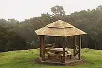
- shelter_type=gazebo - a pavilion structure, sometimes octagonal or turret-shaped, often built in a park, garden or spacious public area
- shelter_type=basic_hut - contained cottage (if it has a fireplace inside then tag it tourism=wilderness_hut instead)
- shelter_type=lean_to - open shelter
- shelter_type=picnic_shelter - A design that provides protection against rain on picnic areas.
- shelter_type=weather_shelter - A structure to protect from rain
- shelter_type=rock_shelter - A rock shelter is a shallow cave-like opening at the base of a bluff or cliff
- shelter_type=public_transport - Small shelters at bus stops or platforms along rail or bus routes
- bench=yes — To specify if there's a bench in the shelter.
- bin=yes — To specify if there's a waste bin in the shelter.
- picnic_table=yes or table=yes — To specify if there's a table in the shelter. Note, that a table does not have benches whereas benches are attached to a picnic table.
- drinking_water=yes/no - Indication whether a feature provides drinking water
- building=* — For shelters that are buildings. building=roof is used for roofs without 4 walls.
- access=* — To denote legal access.
- lockable=yes/no — Can the shelter be locked?
- locked=yes/no — To describe physical access, e.g. a door is locked. This tag is currently not widely used.
- surface=* or floor:material=* — To map the composition of the ground. There is currently no standard on how to map this. surface=* is used a little more often than floor:material=*. See https://overpass-turbo.eu/s/18PK.
To map whether a feature provides shelter, the key shelter=* is used, e.g. for a bus stop, it is also possible to use highway=bus_stop + shelter=yes
Alternative rendering for bus shelter
This is a rendering proposal for your own map:

16px: ![]()
32px: ![]()
See also
- covered=* - A property to denote if an object is covered by something
- tourism=alpine_hut - Alpine hut, where you can eat and sleep
- tourism=wilderness_hut - Wilderness hut, unserviced, but with an internal fireplace
- building=barn - An agricultural building used for storage and as a covered workplace
- building=cabin - A small, roughly built house typically found in rural areas
- building=hut - A small and crude shelter
- building=shed - A small, simple structure used as storage or workshop
- tourism=picnic_site - A locality that is suitable for outdoors eating, with facilities to aid a picnic such as tables and benches
- leisure=picnic_table - A table with benches for food and rest
This article is issued from Openstreetmap. The text is licensed under Creative Commons - Attribution - Sharealike. Additional terms may apply for the media files.