Tag:aeroway=apron
 |
| Description |
|---|
| An area of an airport where planes are parked, unloaded or loaded, refueled, or boarded |
| Rendering in OSM Carto |
 |
| Group: Aeroways |
| Used on these elements |
| Useful combination |
| Status: approved |
| Tools for this tag |
|
An ![]() apron or ramp is the surfaced part of an airport where planes park.
apron or ramp is the surfaced part of an airport where planes park.
Aprons are usually well visible on aerial and satellite imagery as an area and can be mapped as aeroway=apron.
How to map
Tags to use in combination
- name=* - The name of the apron. On larger airports, there may be several different aprons for different use (passenger/cargo/mechanical service) or for different terminals.
- surface=* - Use this tag to define the surface of the apron. Examples: paved, sand, grass, gravel, snow, unpaved.
- ref=* The reference number / identifier of the apron
- Further features can be drawn on the apron
- aeroway=gate - gates
- aeroway=parking_position - parking positions on nodes
- aeroway=parking_position - parking lane on way
- aeroway=taxiway - marked taxiway for aircraft
Example
| Picture/description | Tags | OSM Carto |
|---|---|---|
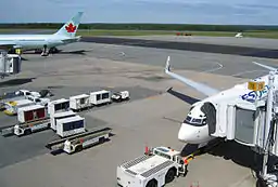
| Apron of the Halifax Airport |
aeroway=apron |
See Munich International Airport for a reference.
| ||||||||||||||||||||||||||||||||||||||||||||||
This article is issued from Openstreetmap. The text is licensed under Creative Commons - Attribution - Sharealike. Additional terms may apply for the media files.