Subdistricts in India
Union territories: Andaman and Nicobar Islands (AN) · Chandigarh (CH) · Dadra and Nagar Haveli (DN) · Daman and Diu (DD) · Delhi (National Capital Territory) (DL) · Jammu and Kashmir (JK) · Ladakh (JK) · Lakshadweep (LD) · Puducherry (PY)
Tagging
Subdistricts of India by state
As of now, there are a total of 6,562 subdistricts, up from the 5,564 in the 2011 Census of India. States use varying names for their subdistricts. Detailed information is as follows:
| State (◊) or Union Territory (●) | Subdistricts | ||||
|---|---|---|---|---|---|
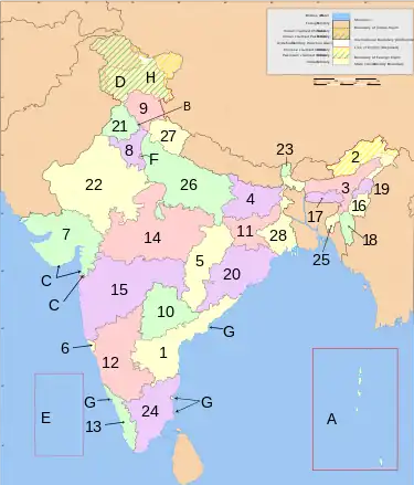
| Map key |
Name | Title[1] | Count | Status | Notes |
| 1 | ◊ Andhra Pradesh | mandal | 679 | 670 mapped CSV WDQuery, OT Query | |
| 2 | ◊ Arunachal Pradesh | circle | 209 | 189 mapped | |
| 3 | ◊ Assam | sub-division | 181 | 180 mapped | |
| 4 | ◊ Bihar | sub-division | 534 | ||
| 5 | ◊ Chhattisgarh | tehsil | 198 | 149 mapped | |
| 6 | ◊ Goa | taluka | 12 | ||
| 7 | ◊ Gujarat | taluka | 270 | 253 mapped | |
| 8 | ◊ Haryana | tehsil | 143 | 110 mapped | |
| 9 | ◊ Himachal Pradesh | tehsil | 180 | 117 mapped | |
| 10 | ◊ Jharkhand | sub-division | 264 | 259 mapped | |
| 11 | ◊ Karnataka | taluka | 236 | ||
| 12 | ◊ Kerala | taluk | 78 | 77 mapped | |
| 13 | ◊ Madhya Pradesh | tehsil | 424 | 389 mapped | |
| 14 | ◊ Maharashtra | taluka | 358 | 355 mapped | |
| 15 | ◊ Manipur | sub-division | 65 | 39 mapped | |
| 16 | ◊ Meghalaya | sub-division | 46 | 42 mapped | |
| 17 | ◊ Mizoram | sub-division | 28 | 27 mapped | |
| 18 | ◊ Nagaland | circle | 120 | 113 mapped | |
| 19 | ◊ Odisha | tehsil | 477 | ||
| 20 | ◊ Punjab | tehsil | 97 | 81 mapped | |
| 21 | ◊ Rajasthan | tehsil | 393 | 326 mapped | |
| 22 | ◊ Sikkim | sub-division | 18 | 9 mapped | |
| 23 | ◊ Tamil Nadu | taluka | 313 | 254 mapped | |
| 24 | ◊ Telangana | mandal | 594 | 589 mapped | |
| 25 | ◊ Tripura | sub-division | 78 | 47 mapped | |
| 26 | ◊ Uttar Pradesh | tehsil | 352 | 314 mapped | |
| 27 | ◊ Uttarakhand | tehsil | 128 | 81 mapped | |
| 28 | ◊ West Bengal | sub-division | 346 | 344 mapped | |
| A | ● Andaman and Nicobar Islands | tehsil | 9 | ||
| B | ● Chandigarh | — | 1 | ||
| C | ● Dadra and Nagar Haveli | — | 1 | ||
| D | ● Daman and Diu | taluka | 2 | ||
| E | ● Delhi | tehsil | 33 | ||
| F | ◊ Jammu and Kashmir | tehsil | 208 | 76 mapped | |
| G | ● Ladakh | tehsil | 15 | 6 mapped | |
| H | ● Lakshadweep | sub-division | 10 | ||
| I | ● Puducherry | commune panchayat | 8 | ||
| 37 | Total for India | 7024 | 6419 | ||
How to download data ?
In order download sub-district data use below link and click run. You can export the data in required format
- Overpass query: too much data; see pages of each state
overpass query for subdistricts without admin_centre: http://overpass-turbo.eu/s/R4Y
- CSV: see pages of each state
- Wikidata pending
References
- ↑ “Statement showing the nomenclature and number of subdistricts in States/Union territories”. Office of The Registrar General and Census Commissioner, India, New Delhi. 2010–2011. Retrieved 2020-04-14.
How to map subdistricts
- - see discussion page
See also
- Districts in India
- Villages in India
- India/Boundaries
 List of tehsils in India
![[W]](../I/Wikidata-logo.svg.png.webp) Wikidata:Country_subdivision_task_force/India/Subdistricts
Wikidata:Country_subdivision_task_force/India/Subdistricts
This article is issued from Openstreetmap. The text is licensed under Creative Commons - Attribution - Sharealike. Additional terms may apply for the media files.