Kosmos max speed rendering
Introduction
This page contains a set of Kosmos rendering rules to highlight the maxspeed values.
- use transparent landuse areas
- colorize maxspeed vales from green (lowest) to red (highest)
- thin grey lines for all highways with no maxspeed value
- show speed values on zoom 14 and higher
URL of the rules to use in Kosmos: http://wiki.openstreetmap.org/index.php?title=Kosmos_max_speed_rendering
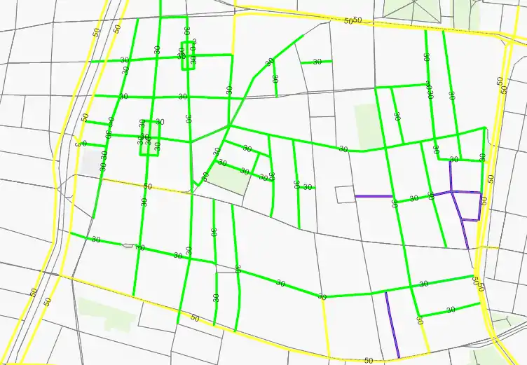
Example: Max_speeds in Vienna's eighth district (Level 15).
Options
| Option | Value | Comment |
|---|---|---|
| MinKosmosVersion | 2.1 | Minimal version of Kosmos needed to use these rules |
| LandBackgroundColor | #F8F8F8 | |
| SeaColor | #B5D6F1 |
Land Areas
| Rule Name | Targets | Selector | Template | Options | Comment |
|---|---|---|---|---|---|
| Coastline | natural=coastline | Polyline (MinZoom=1, Color=#8BCCE5, Width=11:1;17:5, Curved=true) | |||
| Wood | natural=wood | Polygon (Color=#7099DB9C) | |||
| Scrub | natural=scrub | Polygon (Color=#7099EE9C) | |||
| Fell | natural=fell | Polygon (Color=#70CDDB69) | |||
| Farm | landuse=farm | Polygon (Color=#70F6EEB7) | |||
| Farmland | landuse=farmland | Polygon (Color=#70F6EEB7) | |||
| Farmyard | landuse=farmyard | Polygon (Color=#70FFFFCC) | |||
| Residential | landuse=residential | Polygon (Color=#70DCDCDC) | |||
| Industrial | landuse=industrial | Polygon (Color=#70FEADB8) | |||
| Commercial | landuse=commercial | Polygon (Color=#70EFC8C8) | |||
| Retail | landuse=retail | Polygon (Color=#70F0DADA) | |||
| Reservoir | landuse=reservoir | Polygon (Color=#70B5D0D0) | |||
| Basin | landuse=basin | Polygon (Color=#70B5D0D0) | |||
| Forest | landuse=forest | Polygon (Color=#70CFECA8) | |||
| Cemetery | landuse=cemetery | Polygon (Color=#70A9CAAE, BackgroundColor=#7075AC7D, HatchStyle=DashedVertical) | |||
| Allotments | landuse=allotments | Polygon (Color=#70CC9900) | |||
| VillageGreen | landuse=village_green | Polygon (Color=#7099FF99) | |||
| Grass | landuse=grass | Polygon (Color=#7099FF99) | |||
| Common | landuse=common | Polygon (Color=#7099FF99) | |||
| Park | leisure=park | Polygon (Color=#70C7F1A3) | |||
| Pitch | leisure=pitch | Polygon (Color=#708AD2AE) | |||
| GolfCourse | leisure=golf_course | Polygon (Color=#707CCC7C) | |||
| Common | leisure=common | Polygon (Color=#70CFECA8) | |||
| Sport | sport=* | Polygon (Color=#708AD2AE) | |||
| ParkingArea | amenity=parking | Polygon (Color=#70FFFF99) | |||
| School | amenity=school | Polygon (Color=#70F0F0D8) |
Water Features
| Rule Name | Targets | Selector | Template | Options | Comment |
|---|---|---|---|---|---|
| Water | natural=water | Polygon (Color=lightblue) | |||
| Marsh | natural=marsh | Polygon (Color=blue, BackgroundColor=#00000000, BorderColor=blue, BorderWidth=1:1;12:1;15:3, HatchStyle=DashedHorizontal) | |||
| River | waterway=river | Polyline (MinZoom=5, Color=lightblue, Width=5:1;10:2;17:14, Curved=true) | |||
| Drain | waterway=drain | Polyline (MinZoom=13, Color=lightblue, Width=13:1;17:6, Curved=true) | |||
| Stream | waterway=stream | Polyline (MinZoom=13, Color=lightblue, Width=13:1;17:6, Curved=true) | |||
| Canal | waterway=canal | Polyline (MinZoom=5, Color=lightblue, Width=5:1;10:1;17:10, Curved=true) | |||
| Riverbank | waterway=riverbank | Polygon (Color=lightblue) | |||
| Land | natural=land | Polygon (Color=white) |
Highways
| Rule Name | Targets | Selector | Template | Options | Comment |
|---|---|---|---|---|---|
| Living Street | highway=living_street | Polyline (Color=#0000ff, BorderColor=#FF0000, Width=3) | |||
| Highway | highway=* | Polyline (Color=gray, BorderColor=gray, Width=1) Text (MinZoom=14, Color=black, TagToUse=maxspeed, FontName=Arial, FontStyle=regular, FontSize=11:6;17:9) | EliminateSeams | ||
| . 10 | IsTaggedWith(e,"maxspeed") AND ValueNum(e,"maxspeed") < 11 | Polyline (Color=#006600, BorderColor=#006600, Width=3) | |||
| . 20 | IsTaggedWith(e,"maxspeed") AND ValueNum(e,"maxspeed") < 21 | Polyline (Color=#00CC00, BorderColor=#00CC00, Width=3) | |||
| . 30 | IsTaggedWith(e,"maxspeed") AND ValueNum(e,"maxspeed") < 31 | Polyline (Color=#00FF00, BorderColor=#00FF00, Width=3) | |||
| . 40 | IsTaggedWith(e,"maxspeed") AND ValueNum(e,"maxspeed") < 41 | Polyline (Color=#CCFF66, BorderColor=#CCFF66, Width=3) | |||
| . 50 | IsTaggedWith(e,"maxspeed") AND ValueNum(e,"maxspeed") < 51 | Polyline (Color=#FFFF33, BorderColor=#FFFF33, Width=3) | |||
| . 60 | IsTaggedWith(e,"maxspeed") AND ValueNum(e,"maxspeed") < 61 | Polyline (Color=#FFCC66, BorderColor=#FFCC66, Width=3) | |||
| . 70 | IsTaggedWith(e,"maxspeed") AND ValueNum(e,"maxspeed") < 71 | Polyline (Color=#FFCC00, BorderColor=#FFCC00, Width=3) | |||
| . 80 | IsTaggedWith(e,"maxspeed") AND ValueNum(e,"maxspeed") < 81 | Polyline (Color=#FF9999, BorderColor=#FF9999, Width=3) | |||
| . 100 | IsTaggedWith(e,"maxspeed") AND ValueNum(e,"maxspeed") < 101 | Polyline (Color=#FF9933, BorderColor=#FF9933, Width=3) | |||
| . 120 | IsTaggedWith(e,"maxspeed") AND ValueNum(e,"maxspeed") < 121 | Polyline (Color=#FF6633, BorderColor=#FF6633, Width=3) | |||
| . xxx | IsTaggedWith(e,"maxspeed") AND ValueNum(e,"maxspeed") > 121 | Polyline (Color=#FF0000, BorderColor=#FF0000, Width=3) |
Other Ways
| Rule Name | Targets | Selector | Template | Options | Comment |
|---|---|---|---|---|---|
| Rail | railway=* | Polyline (MinZoom=14, Color=gray, BorderColor=gray,DashStyle=DashDot, Width=1) | EliminateSeams | ||
| Border | boundary=administrative | ||||
| .level2 | admin_level=2 | Polyline (MinZoom=1, Color=red, DashStyle=DashDot, Width=2) | |||
| .level4 | admin_level=4 | Polyline (MinZoom=10, Color=red, DashStyle=DashDot, Width=2) | |||
| .level8 | admin_level=8 | Polyline (MinZoom=12, Color=red, DashStyle=Dot, Width=2)) | |||
| .* | Polyline (MinZoom=12, Color=red, DashStyle=DashDot, Width=2) | ||||
| Runway | aeroway=runway | Polyline (MinZoom=14, Color=#BBBBCC, Width=11:1;17:30) | |||
| Taxiway | aeroway=taxiway | Polyline (MinZoom=14, Color=#BBBBCC, Width=12:1;17:10) |
Places
| Rule Name | Targets | Selector | Template | Options | Comment |
|---|---|---|---|---|---|
| PlaceCountry | place=country | Text (MinZoom=3, MaxZoom=7, Color=black, TagToUse=name, FontName=Trebuchet MS, FontStyle=bold, FontSize=3:7;7:20, OutlineColor=white) | |||
| PlaceCity | place=city | Text (MinZoom=7, MaxZoom=14, Color=black, TagToUse=name, FontName=Trebuchet MS, FontStyle=bold, FontSize=7:10;17:30, OutlineColor=white, OutlineWidth=20%) | |||
| PlaceTown | place=town | Text (MinZoom=10, MaxZoom=15, Color=black, TagToUse=name, FontName=Trebuchet MS, FontStyle=bold, FontSize=10:10;17:25, OutlineColor=white) | |||
| PlaceVillage | place=village | Text (MinZoom=12, MaxZoom=16, Color=black, TagToUse=name, FontName=Trebuchet MS, FontStyle=bold, FontSize=12:10;17:20, OutlineColor=white) | |||
| PlaceIsland | place=island | Text (MinZoom=12, MaxZoom=16, Color=black, TagToUse=name, FontName=Trebuchet MS, FontStyle=bold, FontSize=12:10;17:20, OutlineColor=white) | |||
| PlaceSuburb | place=suburb | Text (MinZoom=13, MaxZoom=16, Color=black, TagToUse=name, FontName=Trebuchet MS, FontStyle=bold, FontSize=13:10;17:20, OutlineColor=white) | |||
| PlaceHamlet | place=hamlet | Text (MinZoom=14, MaxZoom=17, Color=black, TagToUse=name, FontName=Trebuchet MS, FontStyle=bold, FontSize=14:8;17:14, OutlineColor=white) | |||
| PlaceLocality | place=locality | Text (MinZoom=14, MaxZoom=17, Color=black, TagToUse=name, FontName=Trebuchet MS, FontStyle=bold, FontSize=14:8;17:14, OutlineColor=white) |
This article is issued from Openstreetmap. The text is licensed under Creative Commons - Attribution - Sharealike. Additional terms may apply for the media files.