Kosmos clean style
Introduction
This page contains a set of Kosmos rendering rules for a "clean" map rendering.
Characteristics:
- grey background
- white roads without border (except motorway)
- no rails whatsoever
- no icons or POIs
That gives a straight, clean impression.
Just a note: I am a bit proud that one of the renderings below was chosen as Featured Image in Week of October 11th 2008 :-)
URL of the rules to use in Kosmos: http://wiki.openstreetmap.org/wiki/Kosmos_clean_style
Examples
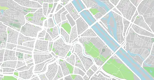
Zoom 12:
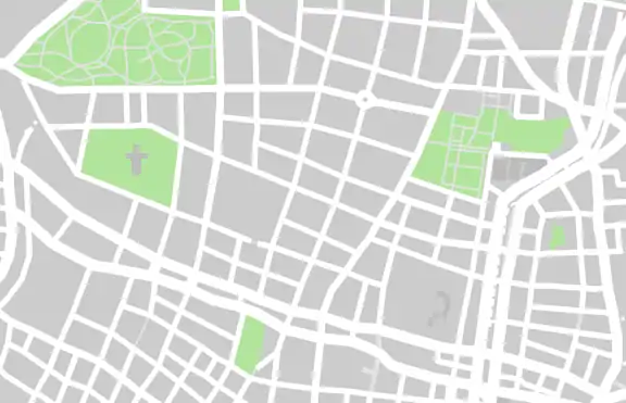
Zoom 14:
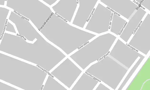
Zoom 17:
Options
| Option | Value | Comment |
|---|---|---|
| MinKosmosVersion | 2.1 | Minimal version of Kosmos needed to use these rules |
| LandBackgroundColor | #cccccc | |
| SeaColor | blue |
Land Areas
| Rule Name | Targets | Selector | Template | Options | Comment |
|---|---|---|---|---|---|
| Coastline | natural=coastline | Polyline (MinZoom=1, Color=#8BCCE5, Width=11:1;17:5, Curved=true) | |||
| Beach | natural=beach | Polygon (Color=#ffbc09) | |||
| Wood | natural=wood | Polygon (Color=#99DB9C) | |||
| Scrub | natural=scrub | Polygon (Color=#99EE9C) | |||
| Fell | natural=fell | Polygon (Color=#CDDB69) | |||
| Farm | landuse=farm | Polygon (Color=#A9CAAE) | |||
| Residential | landuse=residential | Polygon (Color=#FFFFFF) | |||
| Industrial | landuse=industrial | Polygon (Color=#bcbcbc) | |||
| Commercial | landuse=commercial | Polygon (Color=#EFC8C8) | |||
| Retail | landuse=retail | Polygon (Color=#F0DADA) | |||
| Reservoir | landuse=reservoir | Polygon (Color=#B5D0D0) | |||
| Basin | landuse=basin | Polygon (Color=#B5D0D0) | |||
| Forest | landuse=forest | Polygon (Color=#CFECA8) | |||
| Cemetery | landuse=cemetery | Polygon (Color=#A9CAAE) | |||
| Allotments | landuse=allotments | Polygon (Color=#A9CAAE) | |||
| Grass | landuse=grass | Polygon (Color=#28d25c) | |||
| School | amenity=school | Polygon (Color=#F0F0D8) Text (MinZoom=15, Color=black, TagToUse=name, FontName=Times New Roman, FontStyle=bold, FontSize=15:6;17:10, TextMode=AreaCenter) | |||
| Skiing | sport=skiing | Polygon (Color=#CDDB69) | |||
| HorseRacing | sport=horse_racing | Polygon (Color=peru) | |||
| Tennis | sport=tennis | Polygon (Color=#A9CAAE) | |||
| Swimming | sport=swimming | Polygon (Color=lightblue) | |||
| Football / Soccer | sport=football | Polygon (Color=#A9CAAE) | |||
| Rugby | sport=rugby | Polygon (Color=#8AD2AE) | |||
| Sport Multi | sport=multi | Polygon (Color=#A9CAAE) | |||
| Park | leisure=park | Polygon (Color=#B2E49C) | |||
| Pitch | leisure=pitch | Polygon (Color=#A9CAAE) | |||
| GolfCourse | leisure=golf_course | Polygon (Color=#7CCC7C) | |||
| Stadium | leisure=stadium | Polygon (Color=#A9CAAE, BorderColor=gray) | |||
| Common | leisure=common | Polygon (Color=#CFECA8) | |||
| ParkingArea | amenity=parking | Polygon (Color=#bcbcbc) |
Water Features
| Rule Name | Targets | Selector | Template | Options | Comment |
|---|---|---|---|---|---|
| Water | natural=water | Polygon (Color=lightblue) | |||
| Marsh | natural=marsh | Polygon (Color=blue, BackgroundColor=#00000000, BorderColor=blue, BorderWidth=1:1;12:1;15:3, HatchStyle=DashedHorizontal) | |||
| River | waterway=river | Polyline (MinZoom=5, Color=lightblue, Width=5:1;10:2;17:14, Curved=true) | |||
| Drain | waterway=drain | Polyline (MinZoom=13, Color=lightblue, Width=13:1;17:6, Curved=true) | |||
| Stream | waterway=stream | Polyline (MinZoom=13, Color=lightblue, Width=13:1;17:6, Curved=true) | |||
| Canal | waterway=canal | Polyline (MinZoom=5, Color=lightblue, Width=5:1;10:1;17:10, Curved=true) | |||
| Riverbank | waterway=riverbank | Polygon (Color=lightblue) | |||
| Land | natural=land | Polygon (Color=white) |
Other Land Features
| Rule Name | Targets | Selector | Template | Options | Comment |
|---|---|---|---|---|---|
| Contours | ele=* | for elevation contours generated by Srtm2Osm | |||
| .Major | ValueNum(e,"ele") % 100 = 0 | Polyline (MinZoom=11, Color=#B0AD8852, Width=11:1;12:2, Curved=true) | Major contours (100m ones) | ||
| .* | Polyline (MinZoom=12, Color=#B0AD8852, Width=1, Curved=true) | all other contours |
Highways
| Rule Name | Targets | Selector | Template | Options | Comment |
|---|---|---|---|---|---|
| HighwayFootway | highway=footway | Polyline (MinZoom=13, Color=#e3e3e3, Width=14:1;17:4) | EliminateSeams | ||
| HighwayFootwayText | highway=footway | Text (MinZoom=15, Color=black, TagToUse=name, FontName=Arial, FontStyle=regular, FontSize=15:6;17:9) | |||
| HighwayPath | highway=path | Polyline (MinZoom=13, Color=#FFDE93, DashStyle=Dash, BorderColor=gray, Width=13:1;17:6) | EliminateSeams | ||
| HighwayPathText | highway=path | Text (MinZoom=15, Color=black, DashStyle=Dash,TagToUse=name, FontName=Arial, FontStyle=regular, FontSize=15:6;17:9) | |||
| HighwaySteps | highway=steps | Polyline (MinZoom=13, Color=white, DashStyle=Dot, Width=13:1;17:6) | EliminateSeams | ||
| HighwayBridleway | highway=bridleway | Polyline (MinZoom=13, Color=#e3e3e3, Width=13:1;17:6) | EliminateSeams | ||
| HighwayBridlewayText | highway=bridleway | Text (MinZoom=15, Color=black, TagToUse=name, FontName=Arial, FontStyle=regular, FontSize=15:6;17:9) | |||
| HighwayCicleway | highway=cycleway | Polyline (MinZoom=13, Color=white, DashStyle=Dash, Width=13:1;17:4) | EliminateSeams | ||
| HighwayUnpaved | highway=unpaved | Polyline (MinZoom=11, Color=#E2E2E2, BorderColor=gray, Width=11:1;14:3;17:10) | EliminateSeams | ||
| HighwayUnpavedText | highway=unpaved | Text (MinZoom=15, Color=black, TagToUse=name, FontName=Arial, FontStyle=regular, FontSize=15:6;17:9) | |||
| HighwayUnsurfaced | highway=unsurfaced | Polyline (MinZoom=11, Color=#E2E2E2, BorderColor=gray, Width=11:1;14:3;17:10) | EliminateSeams | deprecated | |
| HighwayUnclassified | highway=unclassified | Polyline (MinZoom=11, Color=white, Width=11:1;13:1;17:10) | EliminateSeams | ||
| HighwayUnclassifiedText | highway=unclassified | Text (MinZoom=16, Color=black, TagToUse=name, FontName=Arial, FontStyle=regular, FontSize=15:6;17:9) | |||
| HighwayPedestrian | highway=pedestrian | Polyline (MinZoom=13, Color=#e3e3e3, Width=14:2;17:10) | EliminateSeams | ||
| HighwayPedestrianArea | highway=pedestrian area=yes | Polygon (MinZoom=13, Color=lightgray, BorderColor=gray, BorderWidth=1) Text (MinZoom=15, Color=black, TagToUse=name, FontName=Arial, FontStyle=regular, FontSize=15:6;17:9, TextMode=AreaCenter) | EliminateSeams | ||
| HighwayPedestrianText | highway=pedestrian | Text (MinZoom=15, Color=black, TagToUse=name, FontName=Arial, FontStyle=regular, FontSize=15:6;17:9) | |||
| HighwayResidential | highway=residential | Polyline (MinZoom=11, Color=white, Width=11:1;13:1;17:10) | EliminateSeams | ||
| HighwayResidentialText | highway=residential | Text (MinZoom=15, Color=black, TagToUse=name, FontName=Arial, FontStyle=regular, FontSize=15:6;17:8) | |||
| HighwayService | highway=service | Polyline (MinZoom=12, Color=white, Width=12:1;13:2;17:6) | EliminateSeams | ||
| HighwayServiceText | highway=service | Text (MinZoom=15, Color=black, TagToUse=name, FontName=Arial, FontStyle=regular, FontSize=15:5;17:9) | |||
| HighwayMinor | highway=minor | Polyline (MinZoom=12, Color=white, BorderColor=gray, Width=12:1;13:2;17:13) | EliminateSeams | ||
| HighwayMinorText | highway=minor | Text (MinZoom=15, Color=black, TagToUse=name, FontName=Arial, FontStyle=regular, FontSize=15:5;17:8) | |||
| HighwayTrack | highway=track | Polyline (MinZoom=11, Color=#E2E2E2, BorderColor=gray, Width=11:1;14:3;17:10) | EliminateSeams | ||
| HighwayTertiary | highway=tertiary | Polyline (MinZoom=10, Color=white, BorderColor=white, Width=10:1;13:1;17:11) | EliminateSeams | ||
| HighwayTertiaryText | highway=tertiary | Text (MinZoom=15, Color=black, TagToUse=name, FontName=Arial, FontStyle=regular, FontSize=15:6;17:8) | |||
| HighwaySecondary | highway=secondary | EliminateSeams | |||
| .Bridge | bridge=yes | Polyline (MinZoom=8, Color=white, BorderColor=white, Width=8:1;10:2;13:6;17:11, BorderWidth=30%) | |||
| .* | Polyline (MinZoom=8, Color=white, BorderColor=white, Width=8:1;10:1;13:5;17:12) | ||||
| HighwaySecondaryText | highway=secondary | Text (MinZoom=15, Color=black, TagToUse=name, FontName=Arial, FontStyle=regular, FontSize=15:6;17:9) | |||
| HighwayPrimary | highway=primary | EliminateSeams | |||
| .Bridge | bridge=yes | Polyline (MinZoom=6, Color=white, BorderColor=white, Width=6:0;11:2;17:14, BorderWidth=10%) | |||
| .* | Polyline (MinZoom=6, Color=white, BorderColor=white, Width=6:0;11:1;17:13) | ||||
| HighwayPrimaryText | highway=primary | Text (MinZoom=15, Color=black, BackgroundColor=white, TagToUse=name, FontName=Arial, FontStyle=bold, FontSize=13:6;17:10) | |||
| HighwayPrimaryLink | highway=primary_link | Polyline (MinZoom=6, Color=white, BorderColor=white, Width=6:1;17:14) | EliminateSeams | ||
| HighwayTrunk | highway=trunk | Polyline (MinZoom=6, Color=white, BorderColor=gray, Width=6:1;17:12) | EliminateSeams | ||
| HighwayTrunkLink | highway=trunk_link | Polyline (MinZoom=6, Color=white, BorderColor=gray, Width=6:1;17:8) | EliminateSeams | ||
| HighwayMotorway | highway=motorway | EliminateSeams | |||
| .Bridge | bridge=yes | Polyline (MinZoom=6, Color=white, BorderColor=gray, Width=6:1;17:12, BorderWidth=30%) | |||
| .* | Polyline (MinZoom=6, Color=white, BorderColor=gray, Width=6:1;17:12) | ||||
| HighwayMotorwayLink | highway=motorway_link | Polyline (MinZoom=6, Color=white, BorderColor=gray, Width=6:1;17:8) | EliminateSeams |
Other Ways
| Rule Name | Targets | Selector | Template | Options | Comment |
|---|---|---|---|---|---|
| BoundaryAdministrative | boundary=administrative | ||||
| .level2 | admin_level=2 | Polyline (MinZoom=1, Color=red, DashStyle=DashDot, Width=1:1;9:1.5;17:6) | |||
| .level4 | admin_level=4 | Polyline (MinZoom=10, Color=black, DashStyle=DashDot, Width=1:1;9:1.5;17:6) | |||
| .level8 | admin_level=8 | Polyline (MinZoom=12, Color=#A4A4A4, DashStyle=Dot, Width=1:1;9:1.5;5:5)) | |||
| .* | Polyline (MinZoom=12, Color=black, DashStyle=DashDot, Width=1:1;9:1.5;17:6) | ||||
| BoundaryNationalPark | boundary=national_park | Polyline (MinZoom=9, Color=green, DashStyle=DashDot, Width=9:1.5;17:6) | |||
| Runway | aeroway=runway | Polyline (MinZoom=11, Color=#BBBBCC, Width=11:1;17:30) | |||
| Taxiway | aeroway=taxiway | Polyline (MinZoom=12, Color=#BBBBCC, Width=12:1;17:10) |
Buildings
| Rule Name | Targets | Selector | Template | Options | Comment |
|---|---|---|---|---|---|
| BuildingResidential | building=residential | Polygon (MinZoom=12, Color=#C6C6C6) | |||
| BuildingAny | building=* | Polygon (MinZoom=13, Color=#bcbcbc), Text (MinZoom=16, Color=black, TagToUse=name, FontName=Arial, FontStyle=regular, FontSize=16:6;17:10, TextMode=AreaCenter) |
This article is issued from Openstreetmap. The text is licensed under Creative Commons - Attribution - Sharealike. Additional terms may apply for the media files.