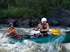
Whitewater sports
![]()
Water sports safety and rescue is best learnt and practised in the safe and managed environment of a recognised training course. Any map information created here, should definitely be considered incomplete and a work in progress. In particular hazards may be missing from the map, or river rapids/sections may be graded inaccurately/incorrectly. This is unavoidable, even in finished well-polished kayaking guidebooks, because rivers can change, however in this case the whitewater maps have only been created after a brief "survey" of the river, and are likely to have omissions.If you don't know about river practise or if a particular river is runnable, don't map it at all.
 |
| Description |
| Whitewater sports for canoeists, rafters and others. |
| Tags |
OpenSeaMap includes information for whitewater sports, including for canoeist, rafters and others. See WikiProject Whitewater Maps to join the people behind this work.
River
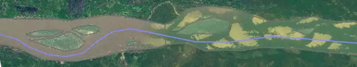
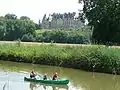
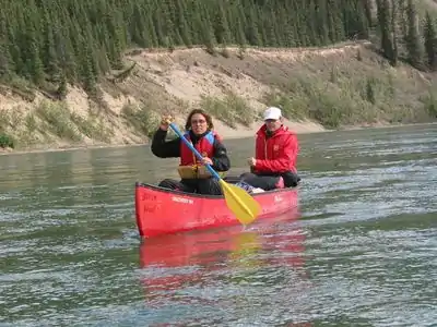
A river is a watercourse that is too wide to jump over. Rivers are wide enough to be traveled by kayak or canoe. Take a waterproof GPS with (or packed waterproof), tie it firmly, and measure the exact course of the river. Note important points (set a track point, describe it by voice recorder, photo), and draw the map.
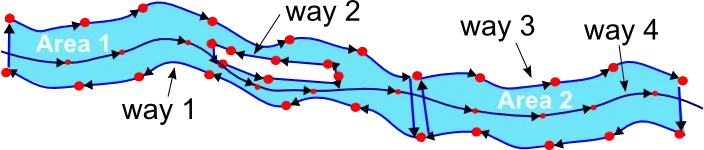
All rivers with width more than 5 meters should be drawn as natural=water+water=river along with a center way with waterway=river.
If there is a tributary: please connect the two waterways together (not only the riverbanks).
| what | how | Key and Value | Icon | Remarks |
|---|---|---|---|---|
| river | waterway=river + width=# + name=* +whitewater:section_grade=# + whitewater:section_name=* | mainwaterline and associated waterlines width of river in meter degree of difficulty name of whitewater section | ||
| water body | natural=water+water=river | rivers broader than 5m | ||
| island | multipolygon | Role: inner |
Grades
These are subjective in the good sense of the term. See the International Scale.
If you don't know a grade or can't decide set it to "unknown". If you don't know about river practise, don't map it at all.
| What | How | Key and Value | Icon | Remarks |
|---|---|---|---|---|
| isolated rapid | whitewater:rapid_grade=# | Grade 0 | 1 | 2 | 3 | 4 | 5 | 6 | ||
| name of rapid | whitewater:rapid_name=* | |||
| sections | whitewater:section_grade=# | section of waterway=river (split in JOSM by <Strg-p>) Grade 0 | 1 | 2 | 3 | 4 | 5 | 6 (see International Scale) Each section starts at a whitewater=put_in or whitewater=put_in;egress, | ||
| name of section | whitewater:section_name=* |
 Grade 0
 Grade 1
 Grade 2
 Grade 3
- Grade 4
 Grade 5
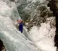 Grade 6
(White water classification follows its own subjectives rules not only described by these pictures, see International Scale)
Danger areas
| What | How | Key and Value | Icon | Remarks |
|---|---|---|---|---|
| Waterfall | waterway=waterfall | for a vertical drop in a stream or river, not navigable by boats. Can also add whitewater:rapid_grade=X or whitewater:rapid_grade=6 if appropriate. | ||
| Sluice | waterway=lock_gate | |||
| Weir | waterway=weir | together with whitewater=rapid_grade, or portage | ||
| Canoe pass | waterway=canoe_pass | If the weir/dam is mapped as a line, the canoe pass should be mapped as a node, at the intersection of the river and the weir/dam. If the dam/weir is mapped as an area, canoe pass can be mapped as a node or a line. | ||
| Single hazard | waterway=hazard | |||
| Restricted section | section of waterway=river | |||
| Restricted Area | Nature protection, power station, etc | |||
| Blocks | ||||
| Hole | ||||
| Sandbank | ||||
| Nature reserve | natural=reserve | |||
| Description | whitewater:description=text | text of interest to canoeists |
 Hole
Hole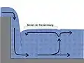 Hole (Modell)
.jpg.webp) Blocks
Blocks Blocks
Access
| What | How | Key and Value | Icon | Remarks |
|---|---|---|---|---|
| Put in | whitewater=put_in | always next to the riverbank | ||
| Egress | whitewater=egress | always next to the riverbank | ||
| Put in / egress | whitewater=put_in;egress | always next to the riverbank | ||
| How to put in | whitewater:put_in;egress=pier whitewater:put_in;egress=rubble whitewater:put_in;egress=sand_strand whitewater:put_in;egress=steps |
pier cobblestones sandy beach steps (stone, concrete) | ||
| Portage | whitewater=egress whitewater=portage_way + Aids whitewater=put_in | egress way boat slide, boat carts, etc. put in | ||
| Parking | amenity=parking |
 Portage
Tourism
| What | How | Key and Value | Icon | Remarks |
|---|---|---|---|---|
| Camp site | tourism=camp_site + name=* | |||
| wild camping permitted | tourism=camp_site + backcountry=yes | |||
| Boat rent | shop=canoe_hire + name=* + building=yes | |||
| WC | amenity=toilets | |||
| Shelter | amenity=shelter | |||
| Fireplace | tourism=picnic_site + fireplace=yes | |||
| Restaurant | amenity=restaurant + name=* + building=yes + barbecue_grill=yes | if barbecue available | ||
| Accommodation | tourism=hostel + name=* + building=yes | + a lot of additional informations |
A selection of additional values have been used in some areas with the whitewater key (see here for an analysis of values used). One used more than 100 times but not listed above is whitewater=portage_way. The key 'canoe' has been used by a few people (analysis) as has the key 'kayak' (analysis). Several suggestions have been made on the talk page for WikiProject_Whitewater_Maps for ways to ensure that this tagging scheme is compatible with tags of use for non-whitewater paddling, including the use of paddlecraft=put_in;egress (for flat-water or sea locations).
There are some existing/developing useful tagging conventions around access information - see details of: access=* or boat=* or canoe=* at Access, and boat=* at Key:boat and also a proposal at Proposed features/access restrictions 1.5.
There are also some existing/developing conventions about water coverage which may be useful (where, for example, an island may only appear occasionally). See Proposed_features/Water_cover.
Whitewater Map
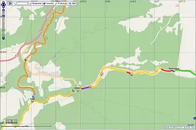
OpenSeaMap shows a Whitewater-chart. Use the "Sport"-layer in menu "View > Sport" with all rivers worldwide. Kayaks and canoeing tours are displayed by colours, according to their difficulty (starting in zoom level = 9). Put in and egress are marked, also hazards and portages. OpenSeaMap is the follower of the British WhiteWater Map. [1] [2]
For alternative methods of viewing rendered maps please see suggestions on WikiProject Whitewater Maps
List of mapped rivers
Please add the international list of mapped rivers
Proposals
- WikiProject_Whitewater_Maps/Proposals - Umbrella proposal for further development of whitewater tagging.
- Proposed features/River Difficulty - Alternative proposal for River Grading tags. Abandoned (inactive)
- Proposed features/Canoe - Related proposal.
References
- ↑ Forth Canoe Club Open WhiteWater Map was a Mapnik rendering by Jonathan Riddell
- ↑ WW-Icons by Stella 2008-07-19