Key:safety rope
 |
| Description |
|---|
| Rope as safety measures in alpine hiking paths |
| Group: Hiking |
| Used on these elements |
| Implies |
| Useful combination |
| Status: approved |
| Tools for this tag |
|
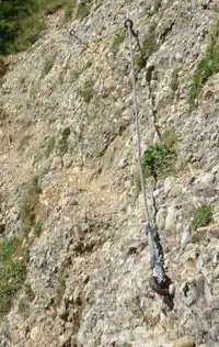
On many hiking trails through mountainous areas, dangerous or difficult sections are secured by technical means like steel cables, fixed ropes, ladders, or rungs. This tag indicates the presence of cable, chain or rope to hold on to.
How to map
- See also: Safety measures on hiking trails
Use safety_rope=yes for parts of hiking trails with a rope. It was propsed use length in meters instead of yes as a value, for example safety_rope=4, but it is also possible to use the standard tags height=* or length=* instead.
This tag is added to an existing highway=path. Short sections can be tagged as node ![]() , longer sections as way
, longer sections as way ![]() .
.
This tag is meant for hiking trails, it shouldn't be used for via ferrata because those ways are secured continuously by technical means.
Main tag
| Key | Value | Element | Description | Example |
|---|---|---|---|---|
| safety_rope | yes / length in m | A cable, chain or rope to hold on to | |
Additional tag
| Key | Value | Element | Description |
|---|---|---|---|
| safety_rope_side | left/right/both | Describes on which side the cable is fastened, in relation to the way's direction. Only applicable if safety_rope=yes (or length value) exists. |
Whole path
If you don't want to split a longer highway=path into several segments to tag their particular safety measures you can add the following tag to the whole highway=path:
| Key | Value | Element | Description |
|---|---|---|---|
| assisted_trail | yes | Way segment with various safety measures |