Key:rungs
 |
| Description |
|---|
| Rungs as safety measures in alpine hiking paths |
| Group: Hiking |
| Used on these elements |
| Implies |
| Useful combination |
| Status: approved |
| Tools for this tag |
|
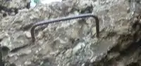
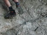
On many hiking trails through mountainous areas, dangerous or difficult sections are secured by technical means like steel cables, fixed ropes, ladders, or rungs. This tag indicates the presence of rungs.
How to map
- See also: Safety measures on hiking trails
Use rungs=yes for parts of hiking trails with rungs, stemples and pins. It was proposed to define the amount of rungs instead of yes as a value, for example rungs=8. It is also possible to use the standard tag height=*.
This tag is added to an existing highway=path. Short sections can be tagged as node ![]() , longer sections as way
, longer sections as way ![]() .
.
This tag was originally invented for hiking trails but might be also usable in combination with highway=via_ferrata.
Main Tag
| Key | Value | Element | Description | Example |
|---|---|---|---|---|
| rungs | yes / amount | Rungs, stemples, pins |
|
Whole Path
If you don't want to split a longer highway=path into several segments to tag their particular safety measures you can add the following tag to the whole highway=path:
| Key | Value | Element | Description |
|---|---|---|---|
| assisted_trail | yes | Way segment with various safety measures |