Key:flood mark
| Description |
|---|
| A flood mark is a point that represents recorded maximum of water table. It is usually a plaque or pole with marked level of flood. |
| Group: Historic |
| Used on these elements |
| Documented values: 2 |
| Useful combination |
| Status: in use |
| Tools for this tag |
|
A flood mark is a point that represents recorded maximum of water table. It is usually a plaque or pole with marked level of flood.
Examples
How to map
Place a node ![]() at the location of the flood mark. Tag with historic=flood_mark and appropriate flood_mark key value:
at the location of the flood mark. Tag with historic=flood_mark and appropriate flood_mark key value:
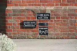
- flood_mark=plaque - as first image above (made of metal, rock, wood),
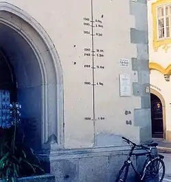
- flood_mark=painting - as second image above,
- flood_mark=engraving - usually inscription (made on rock, wall),
- flood_mark=pole - usually with several marks,
- flood_mark=yes - otherwise.
Tags to use in combination
- historic=flood_mark - historical significance
- flood_date=* - the date of the flood written as yyyy-mm-dd (alternatives: yyyy-mm and yyyy); following date=* syntax
- inscription=* - the text of an inscription that may be found on the flood mark
- location=* - indoor, outdoor
- source=* - source of information
- note=* - additional information
- tourism=attraction
Related tags
This project is continuation and extension of Key:high_water_mark. Within few weeks high_water_mark will be replaced (merged).
- historic=highwater_mark (lower use)
This article is issued from Openstreetmap. The text is licensed under Creative Commons - Attribution - Sharealike. Additional terms may apply for the media files.