Edmonton Transit Service
- Main article: Edmonton Metropolitan Region public transit
 | |
| Status | In progress |
|---|---|
| Description |
|---|
| Indicates a bus stop, LRT station or stop, route, or station serviced by ETS. |
| Group: Properties |
| Used on these elements |
| Useful combination |
|
| Status: de facto |
| Tools for this tag |
|
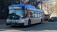
Edmonton Transit Service (ETS), formerly the Edmonton Transit System, is the transit operator for Edmonton. It operates 2 modes of transportation: light rail transit (LRT) and buses. The system has been partially mapped, but many routes if mapped continue to use the older PTv1 scheme and/or reflect the pre-2021 network.
A network tag preset is available for ETS bus stops and routes through the Name Suggestion Index (NSI); this is being extended to the LRT.
Tags
Routes
Routes are mapped using the PTv2 scheme, but some routes are still mapped using PTv1 (usually pre-2021 routes which haven't been updated).
ETS bus routes are usually tagged like this:
| Key | Value |
| type=* | route |
| route=* | bus |
| network=* | ETS |
| name=* | ETS ###: terminus A → terminus B (optional: via midpoint) |
| operator=* | Edmonton Transit Service. Add other operators if applicable (e.g. Spruce Grove Transit on routes 560 and 561, Fort Sask Transit on route 580) |
| ref=* | ### |
| colour=* | line colour as used in network maps and/or GTFS data. Most routes should use blue. Others are:
|
For the LRT, services are mapped like this:
| Key | Value |
| type=* | route |
| route=* | light_rail |
| network=* | ETS |
| name=* | <line name>: terminus A - terminus B |
| operator=* | Edmonton Transit Service |
| ref=* | internal reference number |
| colour=* | line colour as used in network maps and GTFS data, that is, blue for the Capital Line and red for the Metro Line. |
Bus stops
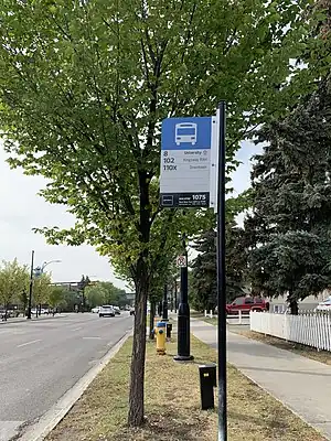
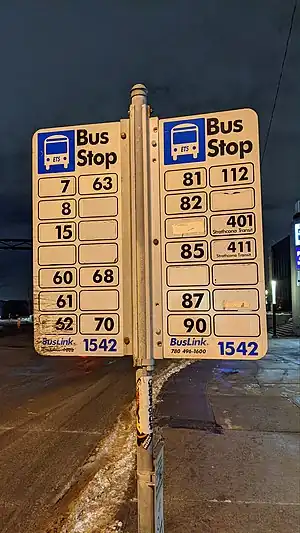
Bus stops names are usually "<north-south road> & <east-west road>" (e.g. 101 Street & Jasper Avenue), following the convention with the operator's GTFS data and ETS Live (with exceptions, e.g. Grove Drive & Spruce Village Way in Spruce Grove), though the data may add directional disambiguation such as NB (northbound), SB (southbound), EB (eastbound), WB (westbound), and bay letter (in stops at transit centres, e.g. Government Centre Transit Centre Bay A). The naming convention is slightly different in the on-board announcements due to space constraints.
| Key | Tag | Value |
| public_transport | platform | Mandatory. |
| highway | bus_stop | Mandatory. Required for the bus stop to render. |
| bus | yes | Mandatory. |
| name | Name | Mandatory. This should generally match the name in ETS's GTFS data and/or the on-board announcements. Most names are in the format "<north-south street> & <east-west road>" (& omitted in on-board announcement). Bus stops in transit centres should be named after the transit centre itself (don't add the bay designation as in the GTFS data such as "Government Centre Transit Centre Bay A"; tag the bay reference with local_ref=*).
|
| ref | Stop ID | Mandatory. This is a four- to five-digit code, found on the lower right corner of the bus stop sign (see photos).
|
| local_ref | Bay designation (on bus stops at transit centres only) | Mandatory. This is a single letter. It is displayed in a blue circle on the top of the bus stop sign.
|
| route_ref | Route references (prominently posted on stops, see photos) | Recommended. This tag should refer to all the bus routes that utilize the stop. This may include regional transit routes (see #Regional routes and Edmonton Metropolitan Region public transit), on-demand transit, school special routes (posted as "School Service", but only at transit centres) and intercity buses (posted under the name of the bus company that operates the route serving that stop e.g. Red Arrow, Rider Express). This should come in handy for verification of mapped routes.
|
| network | ETS | |
| operator | Edmonton Transit Service | Add other operators serving the stop as applicable (e.g. St. Albert Transit, Strathcona County Transit, Spruce Grove Transit, Rider Express). Optional tag |
Light rail
All current LRT lines mapped, as well as the future Valley Line between downtown and Mill Woods:
| Line number | Name | Termini | Relation | Notes |
|---|---|---|---|---|
| 21R | Capital Line | Clareview - Century Park | N: 9730135 |
|
| 22R | Metro Line | NAIT - Health Sciences/Jubilee | N: 6305415 |
|
Bus
Some bus routes under the 2021 network redesign have been mapped, some of which being modifications of pre-2021 routes (e.g. route 8 Abbottsfield - University). All routes listed here are as of 2022 (latest change being route 510X renumbered to route 73).
Network relation: 11515681![]() 11515681
11515681
Frequent
| Route no. | Route description | Relation | Notes |
|---|---|---|---|
| 1A | Downtown - Capilano via Gold Bar | E: 9620584 | |
| 1B | Downtown - Capilano via Terrace Heights | E: 12622682 | |
| 2 | West Edmonton Mall - Stadium | E: 11128771 | |
| 2-Owl | West Edmonton Mall - Clareview | E: 12629650 | Stadium-Clareview leg serves as late-night replacement for Capital Line LRT. |
| 3 | Westmount - Stadium | E: 7709167 | |
| 4 | Lewis Farms - Capilano | E: W: | |
| 5 | Westmount - Coliseum | E: 13768583 | |
| 6 | Davies - Southgate | E: W: | Formerly terminated at Millgate Transit Centre. |
| 7 | West Edmonton Mall - Downtown | E: 12591604 | Formerly terminated at Jasper Place |
| 8 | Abbottsfield - University | N: 14593488 | Formerly ran between Eaux Claires and Mill Woods until replacement of Downtown - Mill Woods leg by route 73 (then 510X) |
| 9 | Eaux Claires - Southgate | N: 14593493 | |
| 9-Owl | Eaux Claires - Century Park | N: 14593491 | Southgate-Century Park leg serves as late-night replacement for Capital Line LRT |
Crosstown
| Route no. | Route description | Relation | Notes |
|---|---|---|---|
| 51 | Castle Downs - University | N: 14681859 | |
| 52 | West Edmonton Mall - Northgate | N: 14676488 | |
| 53 | Clareview - Mill Woods | N: S: | |
| 54 | West Edmonton Mall - Clareview | E: 11515387 | Former route 137 |
| 55 | West Edmonton Mall - Meadows | E: 14877713 | |
| 56 | Mill Woods - West Edmonton Mall | E: 14677113 | Former route 23 |
| 73 | Downtown - Mill Woods | N: S: | Former express route 510X. Created to replace the Downtown - Mill Woods leg of route 8, which has been truncated to University Transit Centre in 2021 network redesign. Considered a cross-town route, but mostly stopping only around future Valley Line LRT stations and is marked orange in system maps and GTFS. To be replaced by LRT. |
Express
| Route no. | Route description | Relation | Notes |
|---|---|---|---|
| 110X | Eaux Claires - Downtown Express | N: 14593489 | |
| 120X | Eaux Claires - Government Centre Express | N: 14596616 | |
| 130X | Baturyn - Government Centre Express | N: 14681675 | |
| 140X | Palisades - Kingsway/RAH Express | N: S: | |
| 150X | Dunluce - Government Centre Express | N: 14681689 | |
| 500X | Meadows - Downtown Express | N: 14877724 | |
| 589 | Coliseum - Waste Management Centre | E: W: | |
| 700X | Century Park - Heritage Valley Express | N: 14604277 | |
| 900X | Lewis Farms - Downtown Super Express | E: 12595708 | Former route 100. Only route labelled "Super Express" (most express routes labelled with just "Express") |
| 910X | Callingwood - South Campus Express | E: W: | |
| 920X | Lewis Farms - University Express | E: 12583185 | |
| 930X | Hamptons - University Express | E: W: | |
| 940X | Downtown - Jasper Place Express | E: 14594086 |
Community/local
Northeast (100-series)
| Route no. | Route description | Relation | Notes |
|---|---|---|---|
| 101 | Abbottsfield - Stadium | N: S: | |
| 102 | Abbottsfield - Kingsway/RAH | E: 14593485 | |
| 103 | Eaux Claires - Kingsway/RAH | N: 14681683 | |
| 104 | Coliseum - Clareview | N: S: | |
| 106 | Dunvegan - Belvedere | E: W: | |
| 107 | Belvedere - Clareview | N S: | |
| 108 | Belvedere - Clareview | N: S: | |
| 109 | Castle Downs - Northgate | N: 14681686 | |
| 111 | Riverdale - Westmount | E: W: | |
| 112 | Eaux Claires - Castle Downs | E: W: | |
| 113 | Clareview - Northgate | E: W: | |
| 114 | Clareview - Northgate | E: W: | |
| 116 | Clareview - Abbottsfield | N: S: | |
| 117 | Clareview - Eaux Claires | E: W: | |
| 118 | Clareview - Eaux Claires | E: W: | |
| 119 | Eaux Claires - Clareview | E: W: | |
| 121 | Clareview - Evergreen | E: W: | |
| 122 | Eaux Claires - Lago Lindo | N: S: | |
| 123 | Northgate - Coliseum | N: 14700222 | |
| 124 | Eaux Claires - Westmount | N: 14681682 | |
| 126 | Castle Downs - Northgate | N: 14700221 | |
| 127 | Castle Downs - White Oaks Square – Northgate | N: 14700219 | Sunday service operates between Northgate and White Oaks Square only. |
| 128 | Northgate - Londonderry | E: W: | |
| 131 | Downtown - Riverdale | E: W: |
Southeast (500-series)
| Route no. | Route description | Relation | Notes |
|---|---|---|---|
| 501 | Capilano - Davies | N: S: | |
| 502 | Davies - South Campus | E: W: | |
| 503 | Davies - Millbourne | N: S: | |
| 504 | Meadows - Davies | N: S: | |
| 505 | Davies - Pylypow Industrial | E: W: | |
| 506 | Davies - Maple | E: 14877711 | |
| 507 | Southgate - Tamarack | E: 14877727 | |
| 508 | Meadows - Millbourne | E: 14877715 | |
| 509A | Mill Woods - Southwood (clockwise) | ||
| 509B | Mill Woods - Southwood (counterclockwise) | ||
| 511-Owl | Mill Woods - Downtown | N: S: | Night service only, replaces route 73 as well as the future Valley Line LRT. |
| 512 | Mill Woods - South Edmonton Common | E: W: | |
| 513 | Mill Woods - Knottwood | E: W: | |
| 514 | Mill Woods - Meyokumin Sakaw | E: W: | |
| 515 | Mill Woods - Meadows | E: 14877719 | |
| 516 | Mill Woods - Meadows | E: 14877717 | |
| 517 | Mill Woods - Southwood | N: S: | |
| 518 | Century Park - Mill Woods | E: W: | |
| 519 | Century Park - Mill Woods | E: W: | |
| 521 | Century Park - Mill Woods | E: W: | |
| 522 | Capilano - Bonnie Doon | N: S: | |
| 523 | Mill Woods - Downtown | N: S: | |
| 524 | Bonnie Doon - Strathearn | N: S: | |
| 525 | Bonnie Doon - Ritchie | N: S: | |
| 526 | Mill Woods - Millbourne/Woodvale | E: W: |
Southwest (700-series)
| Route no. | Route description | Relation | Notes |
|---|---|---|---|
| 701 | Kingsway/RAH - Southgate | N: 14596618 | Some trips run to Government Centre only. |
| 702 | South Campus - Southgate | N: S: | |
| 703 | Leger - South Campus | N: 11128773 | |
| 704 | Southgate - South Park | E: W: | |
| 705 | Southgate - Century Park | N: S: | |
| 706 | Southgate - Leger | E: W: | |
| 707 | Southgate - Century Park | N: 14677102 | |
| 708 | Southgate - Century Park | N: S: | |
| 709 | Southgate - Century Park | N: 14677109 | |
| 712 | Century Park - Yellowbird | E: W: | |
| 713 | Century Park - Twin Brooks | E: W: | |
| 715 | Century Park - Leger | E: W: | |
| 716 | Century Park - Leger | E: 14677103 | |
| 717 | Century Park - Leger | E: 14677107 | |
| 718 | Century Park - Leger | E: 14677111 | |
| 719 | Century Park - Chappelle | N: S: | |
| 721 | Century Park - Desrochers | N: S: | |
| 722 | Century Park - Allard | E: W: | |
| 723 | University - Parkallen | N: 14877821 | |
| 724 | Leger – South Campus | E: W: | |
| 725 | Southgate - Lendrum | ||
| 726 | Belgravia - University | N: 14877823 | Northbound trip makes a loop at Windsor Park before returning to University. |
Northwest (900-series)
| Route no. | Route description | Relation | Notes |
|---|---|---|---|
| 901 | Jasper Place - Downtown | E: 14685749 | |
| 902 | NAIT - University | N: 14593483 | |
| 903 | Jasper Place - Kingsway/RAH | E: 14699859 | |
| 904 | West Edmonton Mall - Westmount | E: W: | |
| 905 | Northgate - Westmount | N: S: | |
| 906 | West Edmonton Mall - Westmount | E: W: | |
| 907 | West Edmonton Mall - Westmount | E: 11515393 | |
| 908 | Jasper Place - Westmount | ||
| 909 | Jasper Place - Westmount | ||
| 912 | Jasper Place - Lewis Farms | ||
| 913 | West Edmonton Mall - Jamieson Place | ||
| 914 | West Edmonton Mall - Jasper Place | E: 11515395 | Former route 14. |
| 915 | West Edmonton Mall - Jasper Place | ||
| 916 | Lewis Farms – West Edmonton Mall | ||
| 917 | Lewis Farms – West Edmonton Mall | E: 12582823 | |
| 918A | West Edmonton Mall – Lessard (clockwise) | ||
| 918B | West Edmonton Mall – Lessard (counterclockwise) | ||
| 919 | Lewis Farms – Secord | ||
| 921 | Jasper Place – Westview Village | ||
| 922 | Lewis Farms – Rosenthal | ||
| 923 | West Edmonton Mall – Oleskiw | ||
| 924 | Jasper Place – Rio Terrace | ||
| 925 | Jasper Place – West Edmonton Mall | E: W: | |
| 994 | West Edmonton Mall – Edmonton Valley Zoo | E: 8244004 | Former route 594. Operates from Victoria Day till the Labour Day weekend only. Weekend and holiday operation Victoria Day till end of June. Daily July through Labour Day weekend. |
Regional
| Route no. | Route description | Relation | Notes |
|---|---|---|---|
| 560 | Edmonton - Spruce Grove | E: 12717158 |
|
| 561 | Edmonton - Acheson | E: W: |
Served by both ETS and Spruce Grove Transit buses. Operated by ETS under contract from City of Spruce Grove. |
| 580 | Clareview - Fort Saskatchewan | N: S: | Operated by ETS under contract from Fort Sask Transit. |
| 747 | Century Park - Edmonton International Airport | N: S: |
School special
| Route no. | Route description | Relation | Notes |
|---|---|---|---|
| 610 | Eaux Claires - Lago Lindo – Killarney | AM: PM: | |
| 611 | Northgate - Archbishop O'Leary | AM: PM: | |
| 612 | Casselman - Queen Elizabeth | AM: PM: | |
| 613 | Dunluce - Archbishop O'Leary | AM: PM: | |
| 614 | Baturyn - Archbishop O'Leary | AM: PM: | |
| 616 | Lago Lindo - Mary Butterworth | AM: PM: | |
| 617 | Eaux Claires - Mary Butterworth | AM: PM: | |
| 620 | Clareview - J.J. Bowlen | AM: PM: | |
| 621 | Schonsee - J.J. Bowlen | AM: PM: | |
| 622 | Coliseum - Concordia University | AM: PM: |