Districts in Chhattisgarh
Union territories: Andaman and Nicobar Islands (AN) · Chandigarh (CH) · Dadra and Nagar Haveli (DN) · Daman and Diu (DD) · Delhi (National Capital Territory) (DL) · Jammu and Kashmir (JK) · Ladakh (JK) · Lakshadweep (LD) · Puducherry (PY)
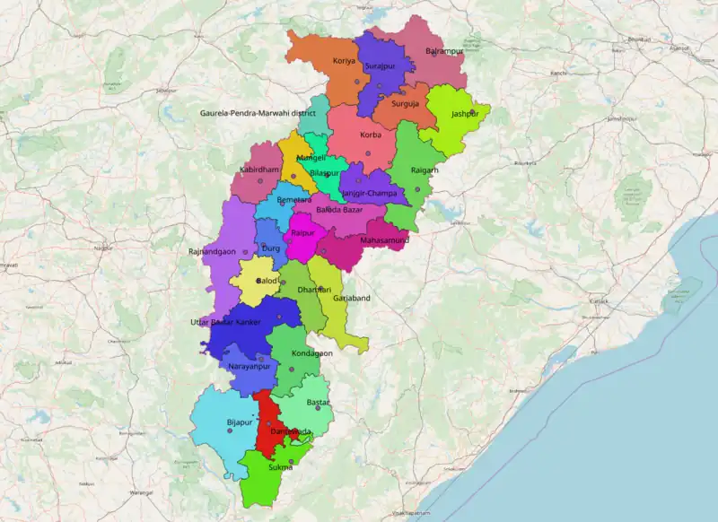
Districts in Chhattisgarh
| Code | District | Relation | Notes | area official(km²) | area OSM(km²) | |
|---|---|---|---|---|---|---|
| ?? | Balod | 95232979523297 | 3,527 | 3,464 | ||
| ?? | Baloda Bazar | 95233809523380 | 4,748 | 4,647 | ||
| ?? | Balrampur | 95234679523467 | 3,349 | 3,342 | ||
| BA | Bastar | 19727171972717 | 6,597 | 5,491 | ||
| ?? | Bemetara | 95242209524220 | 2,855 | 2,871 | ||
| BJ | Bijapur | 95241429524142 | 6,562 | 8,842 | ||
| BI | Bilaspur | 19721761972176 | 5,816 | 5,498 | ||
| DA | Dantewada | 19727181972718 | 3,411 | 3,134 | ||
| DH | Dhamtari | 19727191972719 | 4,084 | 4,058 | ||
| DU | Durg | 19726881972688 | 2,719 | 2,324 | ||
| ?? | Gariaband | 95234169523416 | 4,839 | 4,843 | ||
| ?? | Gaurela-Pendra-Marwahi | 1033009910330099 | ||||
| JC | Janjgir-Champa | 95242549524254 | 3,853 | 3,878 | ||
| JA | Jashpur | 19721321972132 | 5,825 | 5,826 | ||
| KW | Kabirdham | 19726891972689 | 4,447 | 4,250 | ||
| Khairagarh Chuikhadan Gandai | 1472267314722673 | |||||
| KK | Kanker | 19727201972720 | 6,513 | 7,177 | ||
| ?? | Kondagaon | 95264309526430 | 5,078 | 4,988 | ||
| KB | Korba | 19726701972670 | 6,615 | 6,618 | ||
| KJ | Koriya | 19721771972177 | 6,578 | 6,624 | ||
| MA | Mahasamund | 19726811972681 | 4,790 | 4,781 | ||
| MANENDRAGARH CHIRIMIRI BHARATPUR | 1476906214769062 | |||||
| MOHLA MANPUR AMBAGARH CHOUKI | 1476906514769065 | |||||
| ?? | Mungeli | 95265139526513 | --- | 2,808 | ||
| NR | Narayanpur | 95264319526431 | 6,913? | 3,974 | ||
| RG | Raigarh | 19726711972671 | 6,154 | 6,120 | ||
| RP | Raipur | 19726821972682 | 2,892 | 2,903 | ||
| RN | Rajnandgaon | 19726941972694 | 8,022 | 8,059 | ||
| Sakti | 1472258714722587 | |||||
| Sarangarh Bilaigarh | 1472264414722644 | |||||
| SK | Sukma | 95240169524016 | 5,898 | 5,482 | ||
| ?? | Surajpur | 95237969523796 | 2,786? | 5,535 | ||
| SJ | Surguja | 19721331972133 | 5,732? | 3,991 | ||
| sum | 130,603 | 131,528 |
This article is issued from Openstreetmap. The text is licensed under Creative Commons - Attribution - Sharealike. Additional terms may apply for the media files.