Districts in Bihar
Union territories: Andaman and Nicobar Islands (AN) · Chandigarh (CH) · Dadra and Nagar Haveli (DN) · Daman and Diu (DD) · Delhi (National Capital Territory) (DL) · Jammu and Kashmir (JK) · Ladakh (JK) · Lakshadweep (LD) · Puducherry (PY)
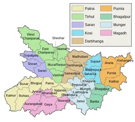
Districts in Bihar, grouped by division.
Tagging
List of districts
| Code | District | Relation | Notes | area official(km²) | area OSM(km²) | In division |
|---|---|---|---|---|---|---|
| BJ | Bhojpur | 19602941960294 | 2,395 | 2,372 | Patna | |
| BU | Buxar | 19631611963161 | 1,624 | 1,709 | ||
| KM | Kaimur | 19631631963163 | 3,363 | 3,343 | ||
| NL | Nalanda | 19631731963173 | 2,367 | 2,335 | ||
| PA | Patna | 19602961960296 | 3,202 | 3,212 | ||
| RO | Rohtas | 19631641963164 | 3,848 | 3,873 | ||
| EC | East Champaran | 17756731775673 | 3,968 | 3,987 | Tirhut | |
| WC | West Champaran | 19601441960144 | 5,229 | 5,250 | ||
| MZ | Muzaffarpur | 19602841960284 | 3,123 | 3,188 | ||
| SO | Sheohar | 19601501960150 | 443 | 450 | ||
| ST | Sitamarhi | 15682651568265 | 2,294 | 2,186 | ||
| VA | Vaishali | 19602891960289 | 2,036 | 2,005 | ||
| SR | Saran | 19602761960276 | 2,641 | 2,652 | Saran | |
| SW | Siwan | 19602651960265 | 2,219 | 2,225 | ||
| DA | Darbhanga | 15682631568263 | 2,279 | 2,284 | Darbhanga | |
| GO | Gopalganj | 19601581960158 | 2,033 | 2,039 | ||
| MB | Madhubani | 15682611568261 | 3,501 | 3,528 | ||
| SM | Samastipur | 19602911960291 | 2,904 | 2,901 | ||
| MP | Madhepura | 19602141960214 | 1,787 | 1,839 | Kosi | |
| SH | Saharsa | 15682621568262 | 1,687 | 1,674 | ||
| SU | Supaul | 15682641568264 | 2,425 | 2,311 | ||
| AR | Araria | 19601731960173 | 2,829 | 2,813 | Purnia | |
| KT | Katihar | 17915271791527 | 3,056 | 3,064 | ||
| KI | Kishanganj | 17907801790780 | 1,884 | 1,955 | ||
| PU | Purnia | 19601871960187 | 3,229 | 3,249 | ||
| BA | Banka | 19720751972075 | 3,020 | 3,093 | Bhagalpur | |
| BG | Bhagalpur | 19602121960212 | 2,569 | 2,560 | ||
| BE | Begusarai | 19631741963174 | 1,918 | 1,941 | Munger | |
| JA | Jamui | 19631831963183 | 3,122 | 3,081 | ||
| KH | Khagaria | 19602231960223 | 1,486 | 1,492 | ||
| LA | Lakhisarai | 19631781963178 | 1,293 | 1,332 | ||
| MG | Munger | 19602371960237 | 1,420 | 1,370 | ||
| SP | Sheikhpura | 19631771963177 | 689 | 606 | ||
| AR | Arwal | 95144499514449 | 634 | 678 | Magadh | |
| AU | Aurangabad | 19631661963166 | 3,389 | 3,276 | ||
| GA | Gaya | 19631671963167 | 4,976 | 4,971 | ||
| JE | Jehanabad | 19631651963165 | 1,569? | 924 | ||
| NW | Nawada | 19631761963176 | 2,494 | 2,487 | ||
| sum | 92,190 | 91,657 |
See also
- Districts in India
- List of districts of Bihar on Wikipedia
- Divisions of Bihar on Wikipedia
- Subdistricts in Bihar
This article is issued from Openstreetmap. The text is licensed under Creative Commons - Attribution - Sharealike. Additional terms may apply for the media files.