Cs:Key:boundary
 |
| Popis |
|---|
| Pro mapování hranic území, hlavně politických, ale také jiných administrativních území. |
| Skupina: Hranice |
| Použité na těchto prvcích |
| Popsané hodnoty: 13 |
| Vhodné kombinace |
| Status: de facto |
| Nástroje |
Použití
- Viz také Hranice
Pro mapování hranic území, hlavně politických, ale také jiných administrativních území. Více informací je na stránce Hranice.
Hodnoty
V tabulce jsou často používané hodnoty klíče boundary=*:
| Klíč | Hodnota | Prvek | Popis | Vykreslování | Ilustrace | |
|---|---|---|---|---|---|---|
Boundary types | ||||||
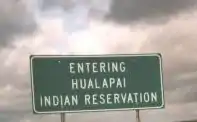
| boundary | aboriginal_lands | A boundary representing official reservation boundaries of recognized aboriginal / indigenous / native peoples. |  |
 | ||
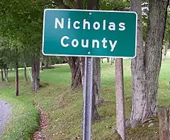
| boundary | administrative | Administrativní hranice (státu, kraje, města). Užívá se spolu s admin_level=*. |  |
 | ||
| boundary | border_zone | A border zone is an area near the border where special restrictions on movement apply. Usually a permit is required for visiting. | _-_crop.jpg.webp) | |||
| boundary | forest | A delimited forest is a land which is predominantly wooded and which is, for this reason, given defined boundaries. It may cover different tree stands, non-wooded areas, highways… but all the area within the boundaries are considered and managed as a single forest. | 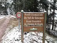 | |||
| boundary | forest_compartment | A forest compartment is a numbered sub-division within a delimited forest, physically materialized with visible, typically cleared, boundaries. | 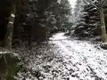 | |||
| boundary | hazard | A designated hazardous area, with a potential source of damage to health, life, property, or any other interest of value. | 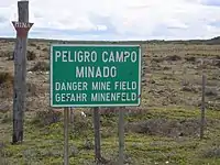 | |||
| boundary | maritime | Námořní hranice | 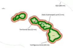 | |||
| boundary | marker | A boundary marker, border marker, boundary stone, or border stone is a robust physical marker that identifies the start of a land boundary or the change in a boundary, especially a change in direction of a boundary. See also historic=boundary_stone | 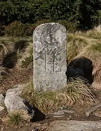 | |||
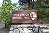
| boundary | national_park | Hranice národního parku, chráněné krajinné oblasti | 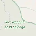 |
 | ||
| boundary | place | boundary=place is commonly used to map the boundaries of a place=*, when these boundaries can be defined but these are not administrative boundaries. | ||||
| boundary | political | Hranice volebního obvodu | ||||
| boundary | postal_code | Hranice podle PSČ. V Česku se nepoužívá. | ||||
| boundary | protected_area | Chráněná oblast (přírodní rezervace, indiánská rezervace, oblast ochrany vodního zdroje, ...) | 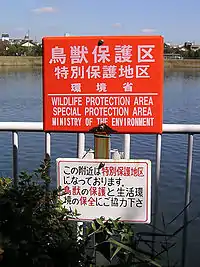 | |||
| boundary | special_economic_zone | A government-defined area in which business and trade laws are different. |  | |||
| boundary | disputed | An area of landed claimed by two or more parties (use with caution). See also Disputed territories. | 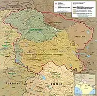 | |||
| boundary | další hodnoty | Další často používané hodnoty najdete pomocí Taginfo. | ||||
Vlastnosti | ||||||
| admin_level | číslo | Přidává se k boundary=administrative a je v rozsahu 1-10 (v Německu i 11) a určuje hierarchii jednotlivých hranic administrativního dělení. |  | |||
| border_type | volena uživatelem | Používá se pro rozlišení mezi různými druhy hranic, pokud na to nestačí admin_level=*. | ||||
| start_date | datum | Užitečná značka, pokud existují vzájemně neslučitelné historické hranice, nebo je hranice relativně nová (nebo vstoupí-li v platnost v blízké budoucnosti) a pokud je ještě nutné odděleně udržovat předchozí hranice (třeba pro statistické mapy založené na starších hranicích). |  | |||
This table is a wiki template with a default description in English. Editable here.
Viz také
Relation:boundary - pro relace hranic
This article is issued from Openstreetmap. The text is licensed under Creative Commons - Attribution - Sharealike. Additional terms may apply for the media files.