California/State Highway Relations
This page describes California state highway route and county highway route relations. Note that Interstate and US routes are distinctly omitted from this page. Interstate and US highways are included in California's statewide highway numbering protocol, as California state routes deliberately do not collide in their numbering with Interstate routes and US routes. See below about "logical extensions" at the boundary of an Interstate route and a California state route which share the same route number.
State Routes
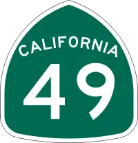

Highways that are officially a State Highway Route with the green ("'49er miner's spade") California numbered highway sign. Use network=US:CA on the route=road relation, along with a ref=* tag with a value of the route number. These vary from one lane for traffic in both directions (e.g. segments of Highway 35 in the Santa Cruz Mountains) to freeway with as many as 12 total traffic lanes, including carpool lanes and parallel entrance/exit lanes (e.g. Highway 91 in Los Angeles, Riverside and San Bernardino Counties) — as well as most possibilities in between. All are fully paved. California state highway numbers do not duplicate Interstate or US highway numbers, unless the state highway is a physically-connected continuation of an Interstate as a "logical extension" (because it does not meet all of the physical standards for an Interstate). To be clear, a "logical extension" isn't actually an Interstate route, it is a state route that does not meet Interstate standards, while deliberately numbered the same as the Interstate, as it may be upgraded to Interstate in the future. For example, State Routes 15, 110 and 210 connect to Interstates respectively so numbered, exactly at the junction where the state route's physical standards fall below minimum Interstate requirements.
The California Department of Transportation (Caltrans) administers signed "Scenic Highways," legislatively defined as part of California's "State Scenic Highway System". Some highways are defined as being "eligible" for becoming a Scenic Highway, but have not (yet) been given this designation. For those highways which are so designated, especially when signed as such (a rectangular sign with an orange California poppy — the state flower — on a medium-blue background with snow-covered dark green mountains in the bottom-background), use network=US:CA:Scenic on a separate route=road relation to designate it as part of this statewide subnetwork. Exactly two California Historic Parkways are defined as a subset of the State Scenic Highway System (network=US:CA:Scenic) and should be additionally tagged with historic=yes.
Use unsigned_ref=* when a State Route exists but is unsigned, as well as to distinguish which State Scenic Highways are which (as some may be unsigned with the Scenic Highway shield). Do use unsigned_ref=* on a designated Scenic Highway route relation which is unsigned with the Scenic Highway shield, but do not use this tag on an "eligible" (but not officially designated by Caltrans) Scenic Highway.
There are also several County Routes — or segments of them — which have been designated "Scenic Highways," the only visible difference being the sign is the same except it is pentagonal instead of rectangular.
1-49
| Route number | Relation | Progress |
|---|---|---|
| 1 | 156504 | North end to San Luis Obispo done. Ventura connection to 101 needs to be completed. (TIGER data are out of date?) |
| 2 | 319538 | |
| 3 | 319600 | |
| 4 | 335190 | |
| 7 | 332406 | border crossing (south end) needs fixes |
| 9 | 358142 | |
| 11 | 6198455 6198456 | SE to border crossing is now (2022-Q3) under construction |
| 12 | 334370 | |
| 14 | 157990 | |
| 15 | 1483011 1483010 | "logical extension" of Interstate 15 between I-8 and I-5. May become part of Interstate 15 in the future. |
| 16 | 334271 334981 | |
| 17 | 309738 161694 | |
| 18 | 349578 | fix routing through Big Bear area |
| 19 | 325714 | |
| 20 | 331392 | |
| 22 | 151658 | |
| 23 | 157999 | |
| 24 | 215687 | |
| 25 | 330674 | |
| 26 | 335030 | |
| 27 | 324392 | |
| 29 | 334675 | |
| 32 | 333576 | |
| 33 | 324682 | |
| 34 | 357734 | |
| 35 | 358161 | |
| 36 | 319745 | |
| 37 | 309717 | |
| 38 | 349579 | |
| 39 | 273982 | |
| 41 | 309983 | |
| 43 | 326916 | |
| 44 | 331114 | |
| 45 | 333595 | |
| 46 | 334722 | |
| 47 | 357315 | partial |
| 49 | 331070 |
52-99
| Route number | Relation | Progress |
|---|---|---|
| 52 | 152267 | |
| 53 | 335124 | |
| 54 | 158001 | |
| 55 | 151673 | |
| 56 | 152734 | |
| 57 | 151622 | |
| 58 | 158220 | |
| 60 | 155931 | |
| 61 | 335541 | |
| 62 | 336887 | |
| 63 | 331088 | |
| 65 | 309751 | |
| 66 | 349539 | |
| 67 | 332003 | |
| 68 | 358079 | |
| 70 | 331086 | |
| 71 | 151836 | |
| 72 | 349553 | partial |
| 73 | 151738 | Toll road |
| 74 | 331873 | |
| 76 | 331822 | |
| 77 | 335615 | |
| 78 | 152727 | |
| 79 | 331829 | partial |
| 82 | 157044 | Started north end |
| 83 | 349536 | |
| 84 | 335071 | |
| 85 | 109570 109571 | Complete |
| 86 | 332331 | |
| 86S | 332581 | future north end of CA 86 |
| 87 | 76279 | Complete |
| 88 | 215685 | |
| 89 | 331103 | |
| 90 | 326011 326012 325937 | |
| 91 | 151632 | Has "toll express lanes" |
| 92 | 158178 | |
| 94 | 154462 | |
| 96 | 355720 | |
| 98 | 332399 | |
| 99 | 2469001 158012 158011 |
102-198
| Route number | Relation | Progress |
|---|---|---|
| 102 | Only in design phase; unconstructed | |
| 103 | 357321 | should mostly be motorway |
| 104 | 334992 | |
| 105 | 8441059 | Might the western portion of this (at merge of I-105) be considered a "logical extension" of Interstate 105? |
| 107 | 358017 | |
| 108 | 331084 | |
| 110 | 319437 | "logical extension" of Interstate 110. May become part of Interstate 110 in the future. From Figueroa Street/Avenue 26 in Los Angeles to Glenarm Street in Pasadena, designated a California Historic Parkway (as well as a National Scenic Byway); the first freeway in the Western USA. |
| 111 | 331994 | South end needs to be fixed |
| 113 | 333772 | |
| 115 | 332438 | |
| 116 | 335103 | |
| 118 | 157987 | |
| 119 | 316932 | |
| 120 | 330991 | |
| 121 | 335096 | |
| 124 | 334984 | |
| 125 | 155367 | Toll road |
| 126 | 309761 | |
| 127 | 337484 | |
| 128 | 335116 | |
| 131 | 357996 | |
| 132 | 335670 | |
| 133 | 151687 151682 | Toll road |
| 134 | 157986 | |
| 135 | 355845 | |
| 136 | 337474 | |
| 137 | 331093 | |
| 138 | 349640 | partial |
| 139 | 332651 | |
| 140 | 7714229 1642781 7714228 | |
| 142 | 349534 | |
| 144 | 356563 | |
| 146 | 326420 | |
| 149 | 331384 | |
| 150 | 356561 | |
| 152 | 325143 | |
| 154 | 355952 | |
| 155 | 330758 | |
| 156 | 357761 | fix intersection with san juan road near Hollister |
| 160 | 335069 | Is it signed through Sacramento? |
| 161 | 332671 | |
| 162 | 333773 339458 | |
| 163 | 151855 | Through Balboa Park in San Diego, designated a California Historic Parkway |
| 164 | 448063 | unsigned; Complete |
| 166 | 355844 | |
| 169 | 355719 | |
| 170 | 309993 | |
| 173 | 349746 | |
| 174 | 331488 | |
| 175 | 335123 | |
| 177 | 336885 | |
| 178 | 326793 337486 | where is west end of east section? |
| 180 | 330949 | |
| 183 | 357759 | |
| 184 | 326762 | |
| 185 | 335613 | |
| 189 | 349767 | |
| 190 | 330770 337475 | |
| 192 | 356011 | |
| 193 | 331087 | |
| 197 | 355820 | |
| 198 | 330676 | |
200+
| Route number | Relation | Progress |
|---|---|---|
| 200 | 355713 | |
| 201 | 331489 | |
| 204 | 326851 | |
| 207 | 335216 | |
| 210 | 158671 | "logical extension" of Interstate 210. May become part of Interstate 210 in the future. |
| 211 | 163687 | almost complete. Northern end unclear. Does it continue left or right? |
| 213 | 358066 | |
| 216 | 334713 | |
| 217 | 357750 | |
| 218 | 358132 | |
| 219 | 335668 | |
| 220 | 2469248 | |
| 221 | 335088 | |
| 225 | 356872 | |
| 229 | 334723 | |
| 232 | 357744 | |
| 236 | 358157 | |
| 237 | 109568 109568 | Complete; has "toll express lanes" |
| 238 | 335636 | At northern end / Castro Valley, connects to (unusually numbered) I-238 and I-580 |
| 241 | 151830 151832 | Toll road |
| 242 | 309701 | |
| 243 | 331935 | |
| 245 | 334712 | |
| 246 | 355934 | |
| 247 | 349627 | |
| 253 | 335153 | |
| 254 | 166583 | in progress |
| 255 | 162119 | complete |
| 261 | 151828 151827 | Toll road |
| 263 | 355747 | |
| 267 | 76331 | Complete |
| 271 | 355694 | |
| 273 | 332645 | |
| 299 | 161078 | |
| 330 | 349574 | |
| 371 | 331835 | |
| 710 | 2471023 | unsigned; a "logical extension?" of I-710 which does not meet Interstate standards. Legislation passed in 2019 authorizes its relinquishment to the City of Pasadena on or after January 1, 2024, which, if/as it happens, should allow this relation to be deleted from OSM. Then, a tidy-up of trunk and expressway tags is in order. |
| 905 | 331516 | Planned to become Interstate 905 in the future; does not meet Interstate standards now (2022) |
County Routes
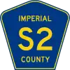

California County Routes are designated by a letter followed by a number (e.g. "S2") on a distinct pentagonal blue shield. The letter indicates the zone the highway route is in (A, B, C, D, E, G, J, N, R, or S). A zone may cover multiple counties or split a county in two.[1] The current county is clearly on the sign using this specific protocol. These "County Routes" are distinct from "State Routes" (numbered highways, above), and are in their own network in OSM. Use network=US:CA:CR.
County Routes — or segments of them — which have also been designated "Scenic Highways" on a separate route=road relation (the only visible difference being the sign is the same except it is pentagonal instead of rectangular) have this designation administered at the state-level by Caltrans along with the county, not solely at the county-level (all other administration / maintenance of County Scenic Routes is at the county-level). Use network=US:CA:CR:Scenic on the separate route=road relation.
A: Lassen, Plumas, Shasta, Siskiyou, Tehama
| Route number | Relation | County | Progress |
|---|---|---|---|
| A1 | 2377508 | Lassen | |
| A2 | 2377519 | Lassen | |
| A3 | 2377530 | Lassen | |
| A5 | 2377531 | Tehama | |
| A6 | 2377532 | Tehama | |
| A7 | 2377533 | Tehama | |
| A8 | 2377534 | Tehama | |
| A9 | 2377535 | Tehama | |
| A10 | 2377509 | Siskiyou | |
| A11 | 2377510 | Tehama | |
| A12 | 2377511 | Siskiyou | |
| A13 | 2377512 | Plumas | |
| A14 | 2377513 | Plumas | |
| A15 | 2377514 | Plumas | |
| A16 | 2377515 | Shasta | |
| A17 | 2377516 | Shasta, Tehama | |
| A18 | 2377517 | Shasta | Portions are part of the State Scenic Highway System |
| A19 | 2377518 | Shasta | |
| A20 | 2377520 | Shasta | |
| A21 | 2377521 | Lassen, Plumas | |
| A22 | 2377522 | Plumas | |
| A23 | 2377523 | Plumas, Sierra | |
| A24 | 2377524 | Plumas, Sierra | |
| A25 | 2377525 | Lassen | |
| A26 | 2377526 | Lassen | |
| A27 | 2377527 | Lassen | |
| A28 | 2377528 | Siskiyou | |
| A29 | 2377529 | Siskiyou | |
B: Butte
| Route number | Relation | County | Progress |
|---|---|---|---|
| B2 | 2377536 | Butte | |
C: Sonoma
This County Route is poorly known but appears to be asserted by Sonoma County, Department of Transportation and Public Works, Roads Division (awaiting confirmation by telephone). It is unsigned. It may have been constructed partially with federal funds, making its classification / categorization as a "County Route" unusual, and helping to keep its existence vague, as it isn't found in (many) datasets which list such road assets, but there is this shield graphic. Some confusion exists.
As the person who writes this here and now, I never got a call back from the County (the various departments I spoke with nor their legal department, who I suggested — the roads department manager liked this — might do some research on some Caltrans-overlap that isn't readily apparant). My research largely indicates there are nine regions in the lettering, three each in northern, central and southern state sub-regions. So C, (C1), seems to be an outlier (making ten). There is a "figment of somebody's imagination" about C1, or at least some understandable vagueness / confusion present. I did not originally enter the route. I am (merely?) doing my best to "keep the situation tidy" as it happened. So, C1 "may be deleted as better data become available." I'd add "easily." Stevea (talk) 21:09, 13 July 2022 (UTC)
| Route number | Relation | County | Progress |
|---|---|---|---|
| C1 | 8499470 | Sonoma | unsigned; continues westerly from west terminus of State Route 128 |
D: Del Norte
| Route number | Relation | County | Progress |
|---|---|---|---|
| D1 | 2377537 | Del Norte | |
| D2 | 2377538 | Del Norte | |
| D3 | 2377539 | Del Norte | |
| D4 | 2377540 | Del Norte | |
| D5 | 2377541 | Del Norte | |
| D6 | 2377542 | Del Norte | |
| D7 | 2377543 | Del Norte | |
| D8 | 2377544 | Del Norte | |
E: Alpine, Amador, Butte, Calaveras, El Dorado, Placer, Plumas, Sacramento, Solano, Tuolumne, Yolo, Yuba
| Route number | Relation | County | Progress |
|---|---|---|---|
| E1 | 2377545 | Alpine | |
| E2 | 2377556 | Placer, Sacramento | |
| E3 | 2377559 | Placer, Sacramento | |
| E4 | 2377560 | Yolo | |
| E5 | 2377561 | Tuolomne | |
| E6 | 2377562 | Yolo | |
| E7 | 2377563 | Sonoma, Yolo | |
| E8 | 2377564 | Yolo | |
| E9 | 2377565 | Sacramento, Yolo | |
| E10 | 2377546 | Yolo | |
| E11 | 2377547 | Yolo | |
| E12 | 2377548 | Sacramento | |
| E13 | 2377549 | Sacramento | Portions are part of the State Scenic Highway System |
| E14 | 2377550 | Sacramento | |
| E15 | 2377551 | Calaveras | |
| E16 | 2377552 | Amador, El Dorado | |
| E17 | 2377553 | Tuolomne | |
| E18 | 2377554 | Calaveras, Tualomne | |
| E19 | 2377555 | Yolo | |
| E20 | 2377557 | Yuba | |
| E21 | 2377558 | Butte, Plumas, Yuba | |
G: Monterey, San Benito, San Luis Obispo, Santa Clara, Santa Cruz
| Route number | Relation | County | Progress |
|---|---|---|---|
| G1 | 2377566 | San Benito | |
| G2 | 156040 | Santa Clara | Complete |
| G3 | 105445 | Santa Clara | Complete |
| G4 | 156039 | Santa Clara | Complete |
| G5 | 1702480 | Santa Clara | |
| G6 | 74885 | Santa Clara | |
| G6 | 74885 | Santa Clara | Complete |
| G7 | 2377578 | Santa Clara | |
| G11 | 2377568 | Monterey, San Benito | |
| G12 | 2377569 | Santa Cruz, Monterey | |
| G13 | 2377570 | Monterey, San Benito | |
| G14 | 2377571 | Monterey, San Luis Obispo | Portions are part of the State Scenic Highway System |
| G15 | 2377572 | Monterey | |
| G16 | 2377573 | Monterey | |
| G17 | 2377574 | Monterey | |
| G18 | 2377575 | Monterey | |
| G19 | 2377576 | Monterey, San Luis Obispo | |
| G20 | 2377577 | Santa Clara | Portions are part of the State Scenic Highway System |
| G21 | 1702479 | Monterey | |
J: Alameda, Calaveras, Contra Costa, Fresno, Kern, Inyo, Mariposa, Merced, Sacramento, San Benito, San Joaquin, Stanislaus, Tulare, Tuolomne
| Route number | Relation | County | Progress |
|---|---|---|---|
| J1 | 2377580 | Fresno, San Benito | |
| J2 | 2377591 | Alameda, San Joaquin | |
| J3 | 2377593 | San Joaquin, Stanislaus | |
| J4 | 2377595 | Alameda, Contra Costa, San Joaquin | |
| J5 | 2377597 | San Joaquin | |
| J6 | 2377599 | San Joaquin, Stanislaus | |
| J7 | 2377600 | Merced, San Joaquin, Stanislaus | |
| J8 | 2377601 | Sacramento, San Joaquin | |
| J9 | 2377602 | Stanislaus, San Joaquin | |
| J10 | 2377581 | Sacramento, San Joaquin | |
| J11 | 2377582 | Sacramento, San Joaquin | |
| J12 | 2377583 | San Joaquin | |
| J13 | San Joaquin | only signed at western terminus as an easterly reassurance shield (near Lammers Road); 11th Street/I-205 Business | |
| J14 | 2377585 | Stanislaus, Calaveras | |
| J15 | 2377586 | Tulare | |
| J16 | 2377587 | Mariposa, Merced, Stanislaus | |
| J17 | 2377588 | Merced, Stanislaus | |
| J18 | 2377589 | Merced, Stanislaus | |
| J19 | 2377590 | Tulare, Fresno | |
| J21 | Tulare | unsigned | |
| J22 | Tulare | unsigned | |
| J23 | 2377592 | Tulare | |
| J24 | Tulare | unsigned | |
| J25 | Tulare | unsigned | |
| J26 | Tulare | unsigned | |
| J27 | Tulare | unsigned | |
| J28 | Tulare | unsigned | |
| J29 | Tulare | unsigned | |
| J30 | 2377594 | Tulare | |
| J31 | Tulare | unsigned | |
| J32 | Tulare | unsigned | |
| J33 | Tulare | unsigned | |
| J34 | Tulare | unsigned | |
| J35 | Tulare | unsigned | |
| J36 | Tulare | unsigned | |
| J37 | Tulare | unsigned | |
| J38 | Tulare | unsigned | |
| J40 | Fresno, Tulare | unsigned | |
| J41 | 2377596 | Inyo, Tulare | |
| J42 | Tulare | unsigned | |
| J44 | Kern, Tulare | ||
| J46 | Tulare | unsigned | |
| J59 | 2377598 | Merced, Stanislaus, Tuolomne | |
| J132 | 2377584 | Mariposa, Tuolumne | |
N: Los Angeles, Orange
| Route number | Relation | County | Progress |
|---|---|---|---|
| N1 | 5692609 | Los Angeles | Portions are part of the State Scenic Highway System |
| N2 | 2377604 | Los Angeles | |
| N3 | 2377605 | Los Angeles | |
| N4 | Los Angeles | ||
| N5 | Los Angeles | ||
| N6 | Los Angeles | ||
| N7 | 2377606 | Los Angeles | |
| N8 | 2377607 | Los Angeles, Orange | |
| N9 | 5692610 | Los Angeles | |
R: Riverside
| Route number | Relation | County | Progress |
|---|---|---|---|
| R2 | 3691011 | Riverside | Complete |
| R3 | 2377609 | Riverside | |
S: Imperial, Orange, Riverside, San Diego
| Route number | Relation | County | Progress |
|---|---|---|---|
| S1 | 2377610 | San Diego | |
| S2 | 1483102 | San Diego, Imperial | Complete |
| S3 | 2377622 | San Diego | |
| S4 | 1491051 | San Diego | Complete |
| S5 | 2377628 | San Diego | |
| S6 | 1373347 | San Diego | Complete (with a break at State Route 76) |
| S7 | 2377629 | San Diego | |
| S8 | 1491075 | San Diego | Complete |
| S9 | 2377631 | San Diego | |
| S10 | 4476369 | San Diego | |
| S11 | 2377611 | San Diego | |
| S12 | 2377612 | San Diego | |
| S13 | 2377613 | San Diego | |
| S14 | 1491046 | San Diego | Complete |
| S15 | 2377614 | San Diego | |
| S16 | 1594400 | Riverside, San Diego | |
| S17 | 2377615 | San Diego | |
| S18 | 938727 | Orange | |
| S19 | 2377616 | Orange | |
| S21 | 2120232 | San Diego | |
| S22 | 1491060 | San Diego | Complete |
| S24 | 2377617 | Imperial | |
| S25 | 14210765 | Orange | Complete |
| S26 | 2377618 | Imperial | |
| S27 | 2377619 | Imperial | |
| S28 | 2377620 | Imperial | |
| S29 | 2377621 | Imperial | |
| S30 | 2377623 | Imperial | |
| S31 | 2377624 | Imperial | |
| S32 | 2377625 | Imperial | |
| S33 | 2377626 | Imperial | |
| S34 | 2377627 | Imperial | |
| S80 | 2377630 | Imperial | |
Unlettered: San Bernardino
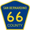
There is a County Route in San Bernardino County which was petitioned by the county to Caltrans to be part of the state-coordinated County Route system, but specifically without a "zone letter." This is signed with the same pentagonal blue shield displaying the name of the (single) county it is in, but emblazoned with simply a number and no "zone letter." So, because of the state coordination (and tangentially, similar signage), this road seems more similar to the "alphanumeric" County Routes (above, in the same section of this wiki), yet distinct from the "numeric only" scheme(s) of individual counties (below, in the next section of this wiki). For these reasons, on this specific route, use network=US:CA:CR.
| Route number | Relation | County | Progress |
|---|---|---|---|
| 66 | San Bernardino | ||
Routes (roads) numbered at the individual county level into a single-county numbered network
This section is "early emerging." As more specific county data become available and better-known, please update relevant sub-sections. This includes creating a new sub-section for any county which has a numbered county road network.
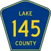
These roads do not fit into the "alphanumeric" network (above, in the previous section), as there are no "zone letters" and these roads are geographically restricted to and are numbered and administered by a single county. They are in their own section in this wiki because they (mostly) diverge from the blue pentagonal signage of the alphanumeric network of County Routes. Exceptionally, the Lake County routes do use blue pentagonal signage, but are not state-coordinated (as is County Route 66 in San Bernardino County, above).
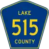
Unlettered: Lake
There are four County Routes in California's Lake County (only) designated using a different scheme than the "lettered zone" system in the rest of the state: they are "unlettered" with no "zone" region and are simply numbered, bypassing alphabetic zoning altogether. It does not appear that these routes or their numbering have any state coordination, rather they are completely administered at the Lake County level. These use the blue pentagonal shield emblazoned with "Lake County" and a number. Use network=US:CA:Lake.
| Route number | Relation | County | Progress |
|---|---|---|---|
| 145 | Lake | ||
| 502 | Lake | ||
| 505 | Lake | ||
| 515 | Lake | ||
Unlettered: Mendocino
California has at least one network of (nearly one thousand) numbered roads (over one thousand miles total) assigned by a single county, in Mendocino County. Currently (2022), none are mapped with route=road relations, though some ways are tagged with ref=*, the value being the number or alphanumeric assigned by the county. These route=road relations should be tagged network=US:CA:Mendocino. These are seldom signed, however signs as reassurance shields (green rectangle with white numbers: 431, 435) have been seen, for example around the Four Corners intersection (near Sinkyone State Wilderness). See the Talk page.
Unlettered: Other counties where roads in a numbered county network might or do exist
There are other counties where numbered roads exist, but it isn't clear whether they are a county network or simply a naming convention. For example, Tulare County has a "Road 150," though what isn't clear is whether this might more accurately be named "County Road 150" (Tulare County being the agency responsible for both naming and administration / maintenance of this road), whether it is signed with a "150" shield (of any style) and whether the road has another (non-numeric) name.
Any other numbered roads belonging to an individual county network in California should be tagged network=US:CA:<county>.
See Also
![[W]](../../I/Wikipedia-16px.png.webp) Portal:California_roads
Portal:California_roads- County routes in California
- California/Freeway_ends
References
- ↑ wikipedia:County routes in California