Brighton and Hove
| V・T・E |
| latitude: 50.8453, longitude: -0.1306 |
| Browse map of Brighton and Hove 50°50′43.08″ N, 0°07′50.16″ W |
| Edit map |
|
External links:
|
| Use this template for your city |
Brighton and Hove is a city in East Sussex, England, United Kingdom at latitude 50°50′43.08″ North, longitude 0°07′50.16″ West.
OSM Coverage
This map includes the City of Brighton and Hove and is defined in OSM as 114085![]() 114085
114085
The natural boundaries of this conurbation are the sea to the South, the South Downs to the East (to Falmer Rd, and including Woodingdean), the South Downs to the North (the A27 effectively), and River Adur on the West. The original northern boundary was south of Patcham but was extended after World War I to prevent pollution to the water table from shack dwellings.
An area of the city centre has all the building outlines drawn in. Clearly this can be expanded. There's also rich POI data which has been input during the various waves of mapping parties. This will require some maintenance. See something out-of-date? Edit the map!
Progress / What could I work on?
Postboxes
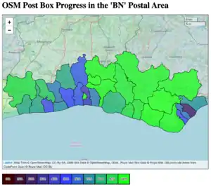
The excellent 'Posthoc' tool shows where Royal Mail says postboxes are. We are trying to reach 100% in all BN regions
Houses
A 10k scan is one of the scanned old maps that National Library of Scotland have allowed us to use. In iD you can add a custom layer with https://geo.nls.uk/mapdata3/os/britain10knatgrid/{zoom}/{x}/{y}.png In JOSM you can add tms:https://geo.nls.uk/mapdata3/os/britain10knatgrid/{zoom}/{x}/{y}.png
The map appears to align very well. As with much of the UK, we still live in old houses and add extensions. Flip between this and Bing aerial imagery to look for new extensions and developments. You will need to realign the Bing aerial imagery slightly.
Building heights are very sparsely populated. OSMBuildings provide a view with extruded buildings to show progress https://osmbuildings.org/?lat=50.82069&lon=-0.13626&zoom=17.0&tilt=30
Parks
The City's parks are mapped, but there is always opportunity to add fine detail.
Cycle infrastructure
Btn Bike Share
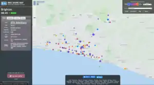
The Btn Bike Share scheme opened in 2017. Some newer locations may need mapping. Tag with:
network=btnbikeshare
operator=??
capacity=n
name=name given by Btn Bike Share
ref=ref given by Btn Bike Share
fee=yes
   area[name="Brighton and Hove"][admin_level=6]->.a;
   node(area.a)[amenity=bicycle_rental][network=btnbikeshare];
   out body;
Progress: checked July 2021
| Ref | Name | Location |
|---|---|---|
| 01 | Brighton Station South | 5071947695 |
| 01d | Upper Gloucester Road / Surrey Street | 5071955472 |
| 02 | Brighton Station North | 5200230509 |
| 03 | New England Quarter | 5053168942 |
| 04 | London Rd Baker St | 5072840926 |
| 05 | North Laine Whitecross Street | 8107297381 |
| 06 | Pavilion Buildings | 5072852666 |
| 07 | Church St | 5072850696 |
| 08 | Old Steine | 5072856703 |
| 09 | Brighton Town Hall | 5200168388 |
| 10 | Brighton Palace Pier | 5072857733 |
| 11 | North St Barclays | 5072860851 |
| 13 | Kings Road Odeon | 5072861657 |
| 14 | Seafront Grand Hotel | 5072866573 |
| 15 | Seafront Metropole | 5072864987 |
| 16 | Seafront Peace Statue | 5072871233 |
| 17 | Brunswick Place | 5072873896 |
| 18 | Palmeira Square | 5200230510 |
| 19 | Sussex County Cricket Ground | 5072875588 |
| 20 | Hove Station | 5072880837 |
| 21 | Hove Town Hall | 5072882195 |
| 22 | Preston Park | 5056099953 |
| 23 | London Road Station | 8949335446 |
| 24 | Preston Barracks | 8949335445 |
| 25 | UoB Cockcroft | 5200230505 |
| 26 | UoS Sports Centre | 5200230507 |
| 28 | UoB Falmer | 5200230508 |
| 29 | The Level (South) | 5072883316 |
| 30 | Edward St | 5072886714 |
| 31 | St Georges Rd Eaton Place | 5072894965 |
| 32 | Madeira Drive | 5072895639 |
| 33 | Royal Sussex County Hospital | 5200230513 |
| 34 | UoB Sports Centre Falmer | 8949335444 |
| 35 | Brighton Marina | 5200230515 |
| 36 | Seven Dials | 5200230516 |
| 36 | Seven Dials Vernon Terrace | 5200230517 |
| 37 | Western Road | 5072897177 |
| 38 | Lewes Rd South Elm Grove | 6792578608 |
| 39 | Lewes Rd Triangle | 5072899663 |
| 40 | Mill View Hospital, Nevill Ave | 8949335443 |
| 41 | UoB Varley Halls | 8949335442 |
| 42 | Rock St | 5072900952 |
| 43 | Hove Lawns | 5072905397 |
| 44 | George St | 5072905573 |
| 45 | UoS York House | 7806994290 |
| 46 | St James St | 5072913797 |
| 47 | Montague Place | 5072912233 |
| 48 | Moulsecoomb Way | 5200230506 |
| 49 | Hove Park | 5072917953 |
| 50 | The Level North | 5072919480 |
| 51 | St Annes Well Gardens | 5072922558 |
| 52 | Grand Parade | 5200230518 |
| 53 | Ewart St | 5072923653 |
| 54 | Harrington Road | 7462540891 |
| 55 | Hartington Road | 5019938504 |
| 57 | The Droveway Hove : Waitrose | 8949335441 |
| 58 | King Alfred | 5722098714 |
| 59 | Hove Lagoon | 5722106427 |
| 60 | Preston Park North | 5722089618 |
| 61 | Eastern Road | |
| 62 | Preston Street | 8949335440 |
| 63 | Connaught Road | 7924294637 |
| 64 | LiDL Arundel Road Brighton | 8949335439 |
| 65 | Portland Rd : Shelley Rd | 7924294639 |
| 66 | Portland Road : School Road | 8949335438 |
| 67 | Portland Road / Glebe Villas | 8949335437 |
| 68 | Portslade Station | 8949335436 |
| 69 | New Church Road : Boundary Road | 8949335435 |
| 70 | New Church Road / Pembroke Gardens | 7918452854 |
| 71 | Rottingdean Seafront | 8949335434 |
| 72 | Tesco New Church Road Hove | 8949335432 |
| 75 | Withdean Rise | 8071452989 |
| 77 | Hove Station North | 8949335428 |
| 78 | Portslade Town Hall | 8949335431 |
| 81 | Wish Road | 8626421515 |
| 99 | Workshop | 5072928673 |
| ?? | Sackville Road / Byron Street | 8949335430 |
| ?? | Brighton General | 8949335426 |
| ?? | East Brighton Park | 8949335427 |
| ?? | Saltdean Lido | 8949335433 |
| ?? | Applesham Avenue | 8949335429 |
| ?? | Stanmer Park Lower Lodges | 8949335425 |
| ?? | Stanmer Park Patchway | 8949335424 |
Cycle Routes:
Brighton has a few cycle lanes & tracks, all of which have relations.
| Relation | Ref | Name | Description |
|---|---|---|---|
| 1950688 |
NCN 2 | National Cycle Network 2
South Coast Cycle Route |
Runs besides the A259 on a cycle track. Along the main seafront part of the A259 main carriageway has been temporally converted to a cycle lane as a response to COVID-19. This is due to be extended in 21/22 and likely to be rebuilt permanently in 23/24. B&HCC aspiration is NCN2 to be a high quality segregated route across its entire length (in B&HCC). |
| 11507779 |
NCN 20 | National Cycle Network 20
London - Brighton |
Follows the A23 from the City boundary all the way to the A259 where it meets the NCN 2 on the seafront. North of the A27 it runs as a segregated cycle/foot track next to the A23. South of the A27 and North of the A270 it runs along the A23 on cycle lanes or on the footway although due to be made into a permanent cycle track in 2022. Between the A270 and the seafront it runs mostly on back streets not very well sign posted except a small new section in valley gardens. This section is also due to be improved in 24/25 |
| 21901 |
NCN 83 | Brighton - Devils Dyke | Runs from NCN 2 at the seafront to Devils Dyke via Hove. Section between NCN 2 and Old Shoreham Road (A270) uses segregated cycle tracks, north of that it runs on residential streets, north of the urban area it runs on the old Dyke railway to the top of the dyke. |
| 21904 |
NCN 90 | National Cycle Network 90
Brighton - Lewes - Polegate |
Runs along the A270 between A23 Valley Gardens (NCN 20) & A27 using cycle lanes.
Runs along the A27 between the A270 Lewes |
| 8376508 |
Old Shoreham Road (A270) Cycle Lanes | A stepped cycle lane runs from Dyke road (A2010) to the Drive. A temp cycle lane also continues to run from The Drive to Hangleton Road (A2038) as a result of COVID-19 measures, this is also planned to be extended to city border in 23/24 or later. | |
| 9302817 |
Dyke Road | Dyke Road has cycle lanes along most of its length, although not of a good quality. | |
| 8376706 |
Undercliff Walk | Running under the cliff beside NCN 2 runs a shared path. This goes between the Marina and Saltdean |
Points of Interest
A Prince Regent's palace
The Royal Pavilion built for King George IV of the United Kingdom 338139685![]() 338139685
338139685
The oldest operating electric railway in the world
The Volks Electric Railway opened in 1883 6168019![]() 6168019
6168019
A couple of piers. One dead
The Palace Pier 3451897![]() 3451897. Local calls it the 'Brighton Pier'.
The West Pier 96651243
3451897. Local calls it the 'Brighton Pier'.
The West Pier 96651243![]() 96651243 which opened in 1866
96651243 which opened in 1866
An abandoned railway tunnel
Not many people will know that there used to be a branch line from near London Road Station to Kemptown incorporating a section of tunnel with an entrance still visible behind a storage depot. 117345347![]() 117345347
117345347
Two Universities
Sussex Uni 37669694![]() 37669694 and Brighton Uni 11799547
37669694 and Brighton Uni 11799547![]() 11799547 both with additional sites
11799547 both with additional sites
Quadrophenia Alley
The alleyway where Phil Daniels and Leslie Ash get 'intimate' in the film Quadrophenia 489251517![]() 489251517
489251517
Twittens
Twitten is an old Sussex dialect word, used in both East and West Sussex, for small passageways leading between two buildings to courtyards, streets, or open areas behind. Black Lion Lane Camden Terrace Clifton Street Passage Duke's Passage Frederick Gardens Ship Street Gardens
and more..
Events and history
Brighton was involved early on in OSM 2006/7
2017 DataVis Brighton Meetup: The Map is not the Territory: OpenStreetMap workshop w/Jez Nicholson
A 1.5hr talk/workshop at The Skiff for members of the Data Visualisation Brighton Meetup group. Participants heard about how capturing geo data is a good way to understand mapping, and made their first edit.
2017 Btn Bike Share scheme mapping
A mini project to map all the locations of the new bike share scheme .
2012 to 2016
AFAIK no events
2011 Mapping Party
Saturday 19 November 2011 with people such as: Smsm1, Derick,nDan Karran, Alex, Emilie, Jez Nicholson
In response to this tweet and this article on the Guardian blog re Skobbler's navigation app lack POIs in Brighton
Photos on Flickr (tag osmbrightonmappingparty2011)
2009 Mapping Party
2007 "Launch" Event
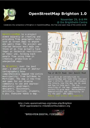
Big OpenStreetMap Brighton "launch" event at the Brighthelm Centre, 29 November 2007.
2007 The Year of Mikel Maron
The project to map Brighton was taken up by User:Mikel in 2006/7 as a Brighton resident at the time. This instigated a flurry of activity, enthusiasm and events.
Animated GIF of the initial mapping 2006/7. Mappers started from the Brighton core and extended out in each direction.
2007 Brighton Stubs Map show locations of "known unknowns", mainly footpaths which couldn't be surveyed while driving through Bevendean.
A number of workshops and presentations took place:
- Presentation at Bar Camp Brighton
- Presentation at University of Sussex
- My Brighton and Hove article on OSM in the New England Quarter
- Sussex Geek Dinner, January 17th
- Mikel gave a presentation at the Running Stitch Pecha Cucha Slides (6 MB) Running Stitch Pecha Cucha words
2006 Pre-DConstruct Workshop
- 27 Nov 2006 - User:Mikel spoke at the Running Stitch Pecha Cucha
- Pre-DConstruct Workshop
- Podcast with Jeremy Keith, pre-Brighton Workshop.
- Big Issue profiled OpenStreetMap, with a bit on Brighton.